In mid-November 2024 Bill, Herman, Ramesh, and I spent four days (Nov 15-18) backpacking in the Grand Canyon along the New Hance and Grandview Trails, with a side excursion to Seventyfive Mile Canyon. Although I had previously day-hiked the Catalinas with Bill and Ramesh, this was our first backpacking trip together (I'd had to bail out of a planned Grand Canyon trip a few years earlier due to an injury) and I was looking forward to this hike.
Day 0: The Drive Up
I headed out as soon as I was done with my class. Herman and I drove up together. Other than a little bit of congestion going through Phoenix—which Herman deftly detoured around—traffic was light and we made good time. We reached Mather Campground a little after dark and set up our tents. Bill and Ramesh, who drove up separately, weren't far behind and arrived soon after. Once they had set up camp, and we had agreed on a start time for our hike the next morning, we headed into our respective tents.
Day 1: The Rim to Hance Rapids
The night was milder than I had expected—I don't think the temperature dropped below freezing. We were up at 4 AM, with the goal of starting down into the Canyon by the time it became light. The huge bright disk of the moon shone down on us like a spotlight as we got ready. We dropped one car off at Grandview Point, parked the other at a pullout near New Hance Trailhead, and started on our hike.
|
|

|
| New Hance Trail (above the Redwall Layer) |

|
Lunch break
(Photo: W. Holliday) |
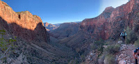
New Hance Trail goes down Red Canyon and is considered to be one of the two hardest trails on Grand Canyon's South Rim (the
other is Boucher). The trail starts out deceptively flat and easy for
the first few hundred yards or so, then—just as one gets used to this—it plunges headfirst down into the
Canyon, dropping about 1,300' of elevation over the first mile. We had
to move carefully down the steep loose rocky trail, but the sky was
clear and the views were gorgeous. We were in shade for much of the
morning, and there was a cold wind that encouraged us to keep our breaks
short.
The steepness eased somewhat below the tall white cliffs of Coconino Sandstone, with a somewhat more moderate descent through the red Hermit and Supai layers, before a headlong dive through the crazy jumble of Redwall Limestone. Below that came the wide swaths of brilliant red Hakatai Shale that give Red Canyon its name and make for what I consider to be one of the most beautiful corners of the Grand Canyon. The vegetation changed as well, the pines at the top giving way to oaks and junipers lower down, then scrubby bushes, shindaggers, and cactus. We reached the floor of Red Canyon around 1:30 PM and stopped for a brief breather. The trail flattened out, and except for one or two scrambles around pouroffs, the last 1½ miles were a pleasant walk to the Colorado River. We reached Hance Rapids around 3 PM.
|
|

|
| New Hance Trail (below the Redwall Layer) |

|
| The cliffs by Hance Rapids |
We hadn't seen a single other hiker all day. To my surprise, the entire area by the river was deserted too—so we had our pick of campsites. We set up camp on a nice flat spot shaded by a couple of large trees. The evening was pleasant and relaxed. Shortly before dark one group of four or five hikers passed by, but other than that it felt like we had the entire Canyon to ourselves.
I was tired and headed into my tent shortly after dinner, around 6.
Day 2: Hance Rapids to Seventyfive Mile Canyon and back
 |
The Colorado just above Hance Rapids
(photo: W. Holliday) |
We got a late start (I overslept), and didn't get on the trail until about 9:30. This was our rest day, and the plan was to hike over to Seventyfive Mile Canyon, about 1½ miles to our east on the Escalante Route. Of course, those 1½ miles involved two notorious sections, Papago Slide and Papago Wall.
On the drive up from Tucson ahead of our hike I had received an email from GCNP Backcountry Information Center (BIC)
saying that, due to a recent landslide at Papago Slide, "What was once a gully full of precariously perched but fairly stable boulders is going through
an adjustment ... this section is now quite loose" and urging us to use caution. Papago Slide was
already well-known for being loose and precarious; for the BIC to feel the situation important enough send email urging caution was disquieting.
The morning had dawned cloudy, and the clouds thickened as we headed along the Escalante Route. We got to the base of Papago Slide not long after. Looking up at the immense pile of boulders was intimidating, but once I started up it didn't feel too different from previous trips. The landslide had buried the upper portion of the Side in a pile of loose rock, and the going got looser and more insecure the higher I got. I was trying to stay on marginally less insecure rubble, and ended up way off where I needed to be at the top; traversing back felt pretty dicey. Bill came up next, moving quickly and confidently and reaching the top in no time. Ramesh found an unorthodox route up the Slide and finished with a free solo first ascent that I would not have been brave enough to try. Herman had a bit of excitement about mid-way up the Slide when two boulders came loose in his hands, one right after the other, and went crashing down between his legs in a cloud of dust. But in the end we all made it up without any problems.

|

|
|
|
Papago Slide
|
 |
Papago Canyon
|
It was a quick walk to Papago Wall. Climbing down the wall didn't seem as mentally challenging as it had the last time I did it. After a brief pause by the river we resumed our hike. The "trail" is rough and not very distinct along this stretch, and had been erased by rockslides in a couple of places, so although we had only a short distance to cover it took us longer than I had expected.
We had lunch sitting on the rocks at the mouth of Seventyfive Mile Canyon, enjoying the warmth of the sunshine with the muted roar of Nevills Rapids in the background, then walked up-canyon for a while. I've enjoyed this slot canyon, with its tormented rock layers, every time I've been there, and this time was no exception. After a while, feeling some post-lunch lethargy, I decided to sit and enjoy the quiet while the others explored up the canyon.

|
Lunch at Seventyfive Mile Canyon Beach
|

|

|
Seventyfive Mile Canyon
|
 |
Papago Wall
|
On our way back we lost the trail above Papago Wall and wandered around for a while trying to figure out where we needed to go (I think we did the exact same thing at the exact same place when hiking the Escalante Route in November 2023). Being off-trail inadvertently in the Grand Canyon backcountry is rarely fun, and we were in especially rough terrain. After thrashing around for a while we eventually stumbled back on the trail, and then it was a short easy walk over to Papago Slide, which brought us to possibly the most intimidating stretch of the entire hike: getting down that mess of loose rocks and rubble.
 |
Bill on Papago Wall
(Photo: R. Karra) |
The traverse at the top of the slide had been obliterated by the landslide, and the descent into the chute felt a little iffy, but once that was done the rest was pretty straightforward. It seemed safest to descend one person at a time, to avoid injuries from loose rocks. This slowed us down a little but we all made it down without any problems.
The walk from the bottom of Papago Slide back to camp was short and uneventful. We had a pleasant evening sitting around, chatting, and making inroads on the bottle of Drambuie.

|
Heading back to camp (Photo: W. Holliday)
|

|

|
Relaxing at camp (Photo: R. Karra)
|
We saw just two pairs of hikers all day: one in the morning as we were setting out towards Seventyfive Mile Canyon, and a pair of hikers who passed through camp not long before it got dark. The latter pair had
no prior experience with either Papago Slide or Papago Wall, and were aiming to get to the beach at Papago Canyon. With darkness not too far, we encouraged them to camp nearby and attempt the Slide and Wall in full daylight the next day: this would have violated their permit but would at least be a lot safer than trying to get negotiate Papago Slide and Papago Wall with darkness falling on an unfamiliar trail. They chose to keep moving.
I headed into my tent a little after 6 PM.
Day 3: Hance Rapids to Hance Creek
We had planned to be on the trail by 7:30, but ended up starting out around 8, which wasn't a big deal since we weren't expecting a strenuous day: a climb of about 1,200 vertical feet over 6.5 miles to Hance Creek. The trail follows the Colorado for a while, starting at river level at Hance Rapids and climbing about 500' over the next mile to the Tonto Platform. It then turns left and heads south, meandering south and west, away from the river, over the next three miles and gradually climbing another 700' until it reaches Hance Canyon. The trail then follows the rim of Hance Canyon for a couple of miles to get to the campsite.
|
|
|
|
|
|
The Tonto Trail: Hance Rapids to Hance Creek
|

The cloudless blue sky and mild temperature made for perfect hiking. We kept up a steady pace other than a couple of short breaks. The views initially were down-canyon and the cliffs on the north side of the Colorado, but as we approached the wide mouth of Hance Canyon it seemed as though the land suddenly opened up into a huge chasm framed by fierce unruly cliffs of dark Vishnu Schist. In a little while, as we hiked along the top of Hance Canyon, the cottonwoods at the bottom of the canyon came into view, little patches of brilliant gold in a landscape of tans and reds. Not long after we were walking down into the campsite.

|

|
Fall colors: Hance Creek
|
Hance Creek was at its lowest level in all the times I've been there.
On previous visits the creek had been wide and full right by camp; this
time it was dry by the camp but appeared as a thin flow a little further
downstream. Considering that we had a La Niña winter coming up, with
warmer and dryer conditions forecast, this was worrisome. There were
several cottonwoods by the stream, beautiful in their golden fall
foliage, and we took our lunch and water filters down to the water and
sat in the weak afternoon sunshine and relaxed. It was a very pleasant
afternoon.
 |
Bill winning at chess (Photo: R. Karra)
|
Eventually we came back up to the main camp area to set up our tents and get camp ready. The temperature dropped quickly as the afternoon wound down. We played a few games of chess (Bill won), had an early dinner, and I was in my tent by 6.
Day 4: Hance Creek to the Rim
The last day of our hike: a climb of 3,700' over a distance of about 4½ miles.. We were up at 5 and on the trail by 7. After a quarter-mile of flat easy Tonto hiking we came to a trail junction: the Tonto continued straight and flat; Hance Creek Trail, leading up to Horseshoe Mesa, headed uphill on the left. We headed uphill..
 | Photo: R. Karra
|
|

|
 | Photo: R. Karra
|
|
|
| The trail up to Horseshoe Mesa |
 |
Photo: R. Karra
|
The trail started out fairly easy but steepened quickly and
relentlessly: we climbed about 1000' in the first mile from the trail junction, half of that in the
last quarter mile. We passed the side trail to Page Spring, paused
briefly by the rusting equipment by Last Chance Mine, then up a steep,
loose, treacherous section through the Redwall layer. As we approached
Horseshoe Mesa the ground was littered with beautiful little grains of
blue- and green-tinted gravel, remnants of the copper minerals that had
attracted miners over a century ago. Then we were atop Horseshoe Mesa,
with all its ominous signs warning of radioactivity. The last time I
had been here, three years earlier, there had been quite a few people
here; today it felt as though we had the entire place to
ourselves—wonderful, but eerie.

I was not physically as fit as I could (and should) have been, and I struggled on the steep climb to the Rim. After an interminable series of cobblestone switchbacks we reached Coconino Saddle, at 6,400' still a thousand feet below Grandview Trailhead, and stopped briefly for a snack. The last thousand vertical feet was a long slow grind: push on somehow to the next bend in the trail, pause briefly until the gasping for air eased a little, then repeat. The views were gorgeous, but mostly I was too busy trying to breathe. Little by little we climbed higher, and then we were at the top and the hike was done. A hot lunch beckoned.
Postscript
The hike—as with every hike I've been on in the Grand Canyon—was delightful. New Hance is widely considered to be one of the top two hardest trails on Grand Canyon's South Rim, and Bill had initially been a little concerned by the many online trail reviews that make it seem like a monster. Happily, the reality turned out to be not quite so bad.
We encountered surprisingly few people on the hike. We saw just one group of four hikers at the very end of the first day, two pairs the second day, a group of four while at Hance Creek, and only a few day hikers while hiking out on Grandview. The solitude was wonderful. I can't wait to go back.