I woke up to a loud chorus of bird calls, none of which I recognized. We broke camp after a leisurely breakfast and were on the trail a little before 8:30. The trail rose gradually for a little while, following the side of the canyon with the creek a couple of hundred feet of steep hillside below, before turning away and heading steeply uphill. After climbing steadily (and steeply) for a while the steepness eased a bit, the forest opened up, and we were treated to beautiful views of Phelps Lake and Snake River.
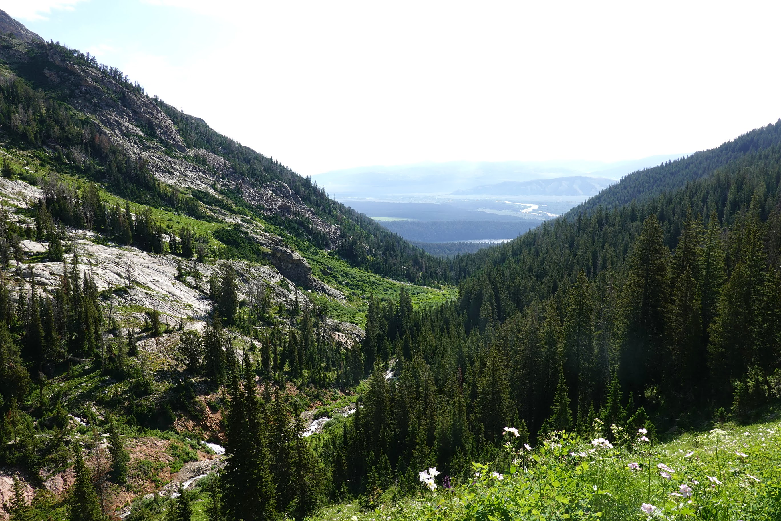
The vegetation thinned and the terrain turned increasingly rocky as we approached Mt. Hunt Divide (about 9,700'), and there were patches of snow on the ground. Going over the saddle at Mt. Hunt Divide was very cool (also literally). After a short break, we headed downhill on the other side of the saddle. Mt. Hunt rose steeply to our right, and the trail was littered with rocks that had rolled down from its side, needing some care to avoid slipping or rolling an ankle.

|

|

|
| Approaching Mt. Hunt Divide |
As we dropped lower the trail gradually softened to a pine-needle-covered forest trail. Entire hillsides were covered with brilliant yellow flowers. It was very pleasant hiking. The sky clouded up with dark grey clouds as we hiked down, and there was a brief sprinkle of rain that soon stopped. Eventually we found a nice campsite. It was early afternoon and we still had a fair bit of day left, but we were in the camping zone on our permit for that night, there was water nearby, and we didn't know how far the next campsite would be, so we decided to stop and set up camp.
It was very breezy all afternoon. The skies had cleared, and the warm sunshine and scudding clouds made a beautiful backdrop to the wildflower-covered hillsides. But once the sun dropped below the high ridges surrounding us, the temperature dropped quickly and the wind felt cold. We had an early dinner and I was in my tent by 7 pm.
Day 3: Granite/Mt. Hunt to Fox Creek
We were on the trail a few minutes after 8. The trail climbed gently for a while (though even the gentle slope left me out of breath fairly quickly due to the altitude), then began to descend steeply into Granite Canyon. We paused briefly at the junction with Granite Canyon Trail, then headed uphill again; Marion Lake was just 1.6 miles and about 900 vertical feet away.
While the streams in Open Canyon all had bridges across them, the creek crossings in Granite Canyon (at least the ones we encountered) were "real": they needed the hiker to actually step into the creek to cross. Interestingly, this made the hike feel a little more "authentic" somehow, despite the potential for wet feet. As it happened. the streams we encountered were all quite shallow and easy to step across—nothing like the creek crossings in Yellowstone—and in the end getting wet wasn't really a problem.
Marion Lake was a stunning little blue-green jewel nestled among steep rocky hillsides. As we enjoyed the view over lunch, we in turn were checked out by a couple of marmots and one very bold and inquisitive chipmunk. A troop of Boy Scouts from Tennessee came up while we were sitting there, which was pretty cool.

|

|
| Marion Lake |
After a short lunch break we continued north towards Fox Creek. We had to go up a short steep uphill stretch of maybe a couple of hundred vertical feet, but the altitude made it slow going and we had to stop fairly frequently to catch our breath. Eventually the trail flattened out and the going got a lot easier. We were now on the Teton Crest Trail (TCT) proper, and it was quite a bit busier than it had been coming up Open Canyon and Granite Canyon.
 |
Bug net
(note hovering mosquito) |
We reached the junction of TCT and Fox Creek Trail in the early afternoon and made camp at a secluded little spot just a few hundred yards down from the trail. At an elevation of 9300′ this was our highest camp so far. The bugs were absolutely ferocious—lots of buzzing flies at first, replaced by swarms of mosquitoes as the day wore down. Even our clothes and bug nets weren't enough to fully protect us! Eventually we dived into our tents around 7 PM, even though it was still bright and sunny, just to get away from the mosquitoes. Of course a bunch of them managed to get into the tent in the process, so there was a bug-killing spree before settling in. Once that was done and I was lying on my sleeping pad, I could see dozens of mosquitoes flying around the mesh inner wall of the tent, looking for a way in.
I woke up once during the night, around 3 AM, and went outside. There was a small half-moon and a pretty display of stars, a pleasant change from the previous two nights when tall trees all around the camp had blotted out much of the sky. It was surprisingly mild, maybe around 40°F, with a cool pleasant breeze—not quite what I had expected given the elevation.
Day 4: Fox Creek to Death Canyon Shelf
 |
| Snow plant |
The day began with a pleasant surprise. As on previous days, we were up at 6 and aiming to be on the trail by 8. We were sitting around having breakfast when a deer with a large head of antlers came by our campsite. It stopped and looked at us for a moment before running up the next hillside.
It was a short uphill walk from Fox Creek to Death Canyon Shelf. We had decided earlier to day hike over to Alaska Basin and then backtrack and go down Death Canyon the next day, so it didn't make sense to carry our packs very far. We found a nice little campsite at the very edge of the shelf, right above a steep drop into Death Canyon far below us, and after a short discussion about whether it would be safe to leave our packs unattended (the marmots seemed active) we dropped our packs and headed out north towards Alaska Basin.
Death Canyon Shelf is a narrow flat-ish strip of land with a sheer 600′ wall of rock one side and a near-vertical 800′ drop down to Death Canyon on the other. The trail wanders across the shelf for about four miles before dropping down into Alaska Basin (which lies outside the national park boundary). On our right (to the east), far below us, is Death Canyon, brilliant green in summer foliage, with the thin thread of Death Canyon Creek meandering across the canyon floor. Across the way the other wall of the canyon rises up, though not quite as steeply, with bright white patches of snow scattered here and there. At this elevation, the vegetation consists mostly of low shrubs with a few scattered clumps of trees. This makes for gorgeous expansive vistas, but means also that the trail is exposed to the sun with little in the way of shade.
 |
| Disappearing flow |
One curiosity of Death Canyon Shelf is that, at many places, a burbling creek coming on the uphill side—very likely snowmelt—simply disappears into the ground as it approaches the trail; there is no corresponding flow of water on the other side of the trail. That is a lot of water to just disappear, so I guess it must emerge as springs flowing into Death Canyon below us. There must be a really interesting maze of underground flows below the Shelf!
The hike across Death Canyon Shelf, without the weight of a pack and with no steep slopes to huff up, was delightful. The sky was cloudless and blue, the sun pleasantly warm, the temperature perfect. The trail was relatively busy, with lots of hikers, most of them heading to Alaska Basin. The only critters we saw were a few marmots, who seemed curious about us but also skittish.
The trail across Alaska Basin led to Basin Lakes, and as we got closer it was clear that there were quite a few hikers milling around the lakes. Nancy and Herman decided to hike on to the lakes, but I didn't want to deal with crowds, and chose to veer off towards a waterfall I had noticed on the South Fork of Teton Creek. It was beautiful, just a short and easy walk from the trail, tucked away behind a small rise that made it hard to see from the trail, and to my delight I had it all to myself. I had lunch with the roar of rushing water drowning out all other sounds, then wandered back to meet Nancy and Herman. We hiked back to our campsite (the wildflowers were very distracting, and I detoured frequently to take pictures), set up camp, had dinner, and headed into our tents around 8.
Day 5: Death Canyon Shelf to Death Canyon
The day began with a close encounter with a marmot. I was standing next to a large boulder cleaning dirt off my trowel when a big fat marmot walked around from the other side of the boulder not five feet from me. It stared at this unfamiliar addition to its landscape for a long time, occasionally tilting its head this way and that. After a while of standing still and staring at each other, I went back to my tent and came back with my camera, and it was still at almost the same place. It was clearly alert and aware of me, but unafraid, and let me tiptoe quite close to it to take pictures. We saw several other marmots on our way to Death Canyon. One sat and posed for us for quite a while, holding a flower in its mouth as though it was going to a dance, before suddenly letting out a loud piercing "Eep!" and diving down a hole between rocks.
The trail leading down into Death Canyon dropped about 800′ down a large steep open expanse bursting with many different kinds of wildflowers. The trail was not steep, but it had a good amount of elevation to lose and not a lot of distance to do it in, so it zigzagged busily through the field of flowers. In many places the vegetation was so thick that it made it hard to see the trail, which looked like a narrow slot cut through a sea of intense green. Every so often we'd catch a whiff of the fragrance of some wildflower. The trail flattened out as we got down into Death Canyon proper and the open landscape transitioned to dense forests of pine and fir. There were still lots of wildflowers, but not as showy and not in the riotous variety of the open fields.

|

|

|

|
| Wildflowers: Upper Death Canyon |
Death Canyon seemed to be set up to accommodate more hiker traffic than the ones we had gone up (Open Canyon and Granite Canyon). There were many more campsites, each labeled with a neat little metal sign that said "Campsite". Creek crossings had sturdy wide log bridges across them, sometimes with extra split logs lying nearby to allow quick repairs. In at least one place there was even a sign pointing towards the bridge so that people wouldn't get lost.
The hiking was easy at this point and we covered ground more quickly than we had expected: the "Leaving Death Canyon camping zone" sign took us by surprise. We could probably have made it to out all the way to the trailhead, but since we didn't have a campground reservation for the night and in any case the quiet seclusion of the forest seemed more appealing, we backtracked and claimed a campsite. It was still early in the day, so we just put our packs down and started on various camp chores. A marmot showed up almost immediately and proceeded to nose around, wandering around surprisingly boldly and nonchalantly even though we were sitting right there. Eventually Herman yelled at it and threw a stick at it to chase it off. This must have hurt its feelings, because it didn't show up again after that.
The trail out of Death Canyon mostly followed the creek, passing through thickly forested terrain at first, then opening up as we dropped lower. It had a gentle grade and made for pleasant and easy hiking.
After about a mile of hiking, as we approached the junction with Alaska Basin Trail, a storm began brewing. Expecting a drenching, we stopped to put on our rain gear. But the storm blew by quickly, and we got only a brief cloudburst. As it happened, that was the heaviest rain we had for the entirety of our hike.
There is a cabin at the trail junction where park employees working on the trail can stay. We stopped outside the cabin to put away our rain gear. One of the people staying there came out and chatted with us for a while. It was interesting to get a perspective on the place from a non-tourist.
The canyon opened up quickly below the trail junction. On our left was a high wall of rocks; on our right the creek, thundering down in a rush of foaming white water; beyond the creek were huge vertical cliffs rising up to the sky. It was majestic. Eventually we reached the junction with the trail that went down towards Phelps Lake, which we had taken almost a week ago when we were headed up towards Open Canyon. This time we headed the other way, up the hill towards the Phelps Lake overlook and then down to the trailhead.
I had never backpacked this sort of terrain before this—in terms of elevation, the steep slopes, the likelihood of summer thunderstorms, the possibility of residual snow or ice making the trail treacherous—and didn't quite know what to expect. We ended up being more cautious and conservative than we needed to be, with hiking distances of about five to six miles a day and elevation changes of around 1,500 to 2,500 feet. The trail ended up being easier than I had expected (maybe I was unconsciously planning for Grand Canyon terrain): we typically started out on the trail at around 8 AM and stopped around 1 PM. We could certainly have planned a more ambitious hike with longer distances. On the other hand, given the campsites on our permit, a more ambitious hike really wouldn't have gotten us further, and it was really quite pleasant to have half the day to relax and enjoy our time there.
I had a surprising amount of gear problems on this hike, though thankfully they were resolved before we hit the trail. I somehow managed to forget to put my hiking poles into Herman's car when we were starting out; we fixed this by stopping and picking up a pair in Flagstaff. Then, at Colter Bay campground the evening before our hike, I discovered that my headlamp wouldn't turn on; this necessitated a walk to a nearby camping store. Although both issues were discovered and fixed before the hike itself, and there were no problems on the trail, they still suggest a lack of care in planning that I find bothersome. I'll have to do better on the next hike, whenever and wherever that is.


No comments:
Post a Comment