
Day 1: Tanner Trailhead to Tanner Beach

The hike across the Supai layer was uneventful, the weather sunny and pleasant. Shortly after 11, we stopped briefly for lunch at the bottom of the Redwall limestone layer, the sheer wall of the Palisades of the Desert hemming us in to the east, the Colorado river a tiny ribbon away to the north of us.

|

|

|
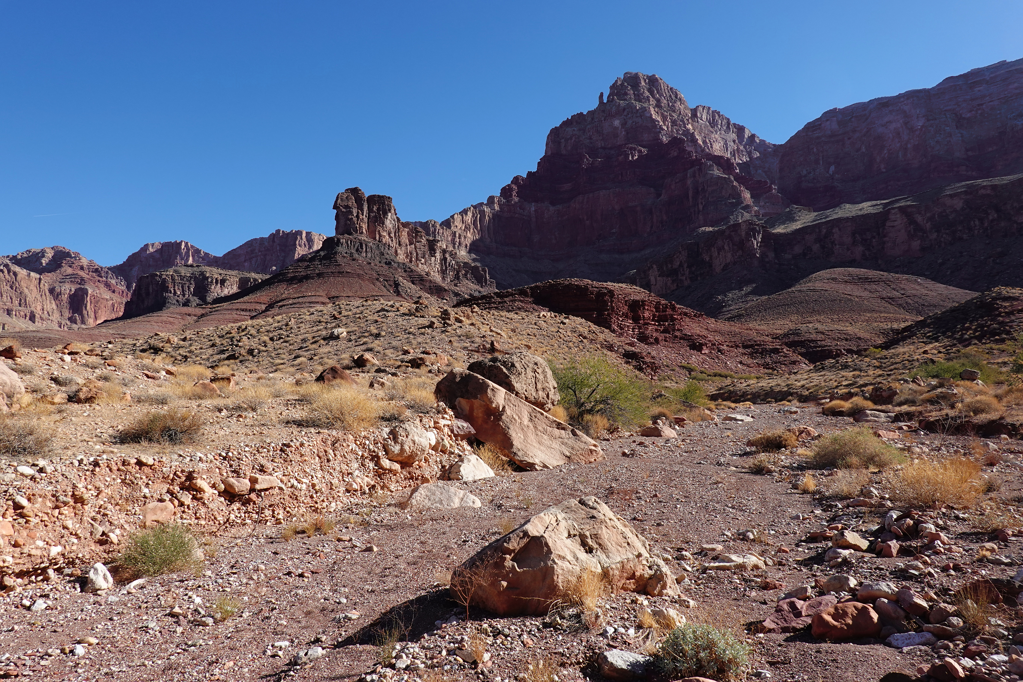
The trail below the Redwall, descending through the Muav and Tapeats, was not too demanding, but by the time we got to the Dox layer of the Supergroup, about a couple of miles from Tanner Beach, I was beginning to get tired. The trail descends steadily (and interminably) through loose broken sandstone -- nothing especially difficult, but needing care when one is tired. We reached Tanner Beach around 2:30.
 |
| Comanche Point |
Days 2 and 3: Tanner Canyon, Cardenas Canyon
Our next camp, over at Cardenas Canyon, was just an easy three-mile hike away, and the cool daytime temps meant that there was no particular rush to get on the trail early. So we spent the morning hiking up Tanner Canyon, which I had seen from above several times while hiking Tanner Trail but had never explored. This turned out to be a very enjoyable stroll. The canyon (the parts we saw) is wide with a gently sloping gravel bed interspersed with large flat beds of deep red-brown Dox sandstone. One intriguing find: Tom spotted drag marks from something being hauled along up the canyon bed; prints on either side suggested that the dragger might be a cat. The marks were quite conspicuous for a while, but ended abruptly on a rocky stretch. We never did figure out what it was. We walked up-canyon for an hour or so, then returned to camp to pack up and head out to Cardenas Canyon.

|
|

|


|

|

|

After breakfast we headed out on a day hike up Cardenas Canyon. The canyon was narrower and slightly steeper than Tanner Canyon, with the occasional "interesting" part, but mostly it was a very pleasant walk up a soft gravel bed.
|
|
|


Back at camp later that afternoon, the clouds that had covered the sky all day gradually began to dissolve; by sundown the skies were mostly clear, portending an even colder night. Another early dinner followed by an early dive into my tent.
Day 4: Cardenas Canyon to Escalante Canyon
To my grateful surprise, the night turned out to be nowhere near as cold as I had feared. I didn't see any stars overhead when I went out briefly around 3 AM, so presumably the clouds had returned overnight. But when I emerged from my tent the skies were clear and blue. And cold, but I was expecting (and resigned to) that. The goal for the day was Seventyfive Mile Canyon, 7 miles away.
After a short climb of about 300' heading west out of Cardenas Beach, the trail contoured south, climbing gradually. We hiked leisurely, detouring to view some prehistoric ruins (to the east) and dramatic clifftop views of the Unkar Delta across the river (to the west).

|

|
The trail trended upward, rising another 500' or so over the next 1.5 miles, then jogged sharply westwards, paralleling Escalante Canyon (though on the other side of the ridge) for roughly a mile before turning south to descend into the (dry) creekbed. This descent, along a thin, loose, poorly marked path down a steep canyonside, finally felt a little more like a "route" compared to the nice smooth easy hiking we had encountered before that.

|

|

After dinner, sitting shivering in the dark watching the stars flicker on one by one, we were treated to the sight of Jupiter and Saturn closing in on each other to the southwest.
Day 5: Seventyfive Mile Canyon


|

|

|
| Lower Seventyfive Mile Canyon | ||
The stretch of Seventyfive Mile Canyon between the Colorado river and the point where the canyon meets the trail is a narrow shadowy slot just a few feet wide. The towering vertical canyon walls block out the sun for much of the day. The rock layers are tortured and twisted and folded into crazy patterns. But above the canyon's junction with the trail it is completely different: it opens up abruptly, the canyon walls drop down to reasonable heights, the sun shines. The first mile or so up-canyon from the river, Seventyfive Mile Canyon twists and turns in a generally southeasterly direction, but after that the main canyon abruptly veers to the east, pointing directly towards the Desert View Watchtower on the Rim. We were walking up the canyon, went around a corner, looked up, and there was the Watchtower far away in the distance! That was very cool.


|
|
| Upper Seventyfive Mile Canyon | |
Jupiter and Saturn seemed close to touching that evening.
Day 6: Seventyfive Mile Canyon to Red Canyon
It's only a mile from Seventyfive Mile Canyon to Papago Canyon, and another mile from Papago to Red Canyon, where the New Hance Trail would take us to the Rim. But that first mile turned out to have the two most challenging parts of the trip: Papago Wall and Papago Slide. I had read about both before the trip, but the readings didn't really prepare me for the reality.

the river before descending steeply into Papago Canyon. After crossing the beach, it then goes straight up a wall of black rock: Papago Wall (different sources give different estimates of its height,ranging from 30 feet to 50 feet). There are plenty of hand- and foot-holds and ledges to stand on, but its near-verticalness was off-putting at first -- in fact, when Tom initially pointed to the ducks indicating where the trail went up the rock face, my first reaction was, "You've got to be kidding me!" (Technically, that was my second reaction. My first reaction is best left unprinted.) But when I put skin to rock, it turned out to be less difficult than it had been intimidating, even with packs on. Tom and I were soon at the top and on our way.
|
||||


About twenty minutes later we came to the Papago Slide. This is a steep narrow chute, maybe 80 or 100 feet high, of loose scree, ranging in size from gravel to small stones to large boulders, perched precariously on this incredibly steep slope and ready to move at the least provocation. Tom went down first, and once he was away from the fall line I followed him down. As with the Papago Wall, all four limbs were involved. Once I began moving, the actual descent wasn't as bad as it had initially seemed, but I was still glad when it was done.
|
|||||||||


Overall, Papago Wall and Papago Slide rank up there among the most intimidating stretches of hiking I've encountered, in the Grand Canyon or elsewhere.

We spent some time at Hance Beach purifying water to take with us for our dry camp that night, then hiked up New Hance Trail to a campsite about 1.6 miles from the river. On either side lay the bright red slopes of Hakatai shale that give Red Canyon its name. Although the weather had warmed slightly over the last few days, the temperature dropped quickly once the sun sank below the clifftops. After our usual early dinner, we finished off our remaining booze (there's no sense hauling it up the 3,700 vertical feet we'd be hiking the next day) and then I ducked into my tent.

|

|

|
Much later, maybe around 9 PM, I was awakened briefly by a pack of foxes yipping in the distance. It was a cool sound for the last night of our trip, but I don't think I lay awake very long.
Day 7: Red Canyon to New Hance Trailhead
Tom fell ill overnight. Our tents were far enough apart that I didn't find out until I went over to talk to him in the morning. Although he didn't feel great, Tom felt that he'd be able to make it to the top on his own. New Hance, considered one of the most difficult South Rim trails in the Grand Canyon, is hard work even for the physically fit; tackling this trail when one is weak and wobbly and running on fumes takes a huge amount of willpower and mental fortitude.
|


We moved slowly, reaching the top of the Redwall around noon and the top of the Coconino layer just as the sun was setting. We finished the last stretch by the light of our headlamps (trailfinding by the light of headlamps in the jumble of rocks at the top is hard!).
We came out of the hike around 7:30 PM.


No comments:
Post a Comment