
The Trail


Day 0: Getting to the Trailhead
I picked up Nirmal and Nicole at their hotel near Sky Harbor Airport, rendezvous'd with Tom at Sunset Point Rest Stop, and headed north towards highway 89A. We had planned to have a late lunch along the way, but the restaurant was closed and, wanting some daylight to set up camp, we decided not to wait. FS 8910, the dirt road leading to the trailhead, was in worse shape than I remembered from our last visit, and my Honda Accord struggled at times.

Days 1 and 2: Trailhead to Nankoweap Creek


We reached Marion Point around 2, sat around for a bit, then set up camp. Nicole was skeptical at first about pitching tents on a tiny postcard-sized campsite with cliffs falling away steeply on three sides, but eventually got used to the idea (the lack of any plausible alternatives may have been a persuading factor).
The rest of the afternoon was lazy. We had an early dinner. The temperature dropped quickly as soon as the sun went behind the cliffs. Between the cold and our fatigue, we didn't wait around very long—I was in my tent by 5:30.

|

|

|
|
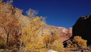
The next morning we were on the trail around 8. It's a little less than six miles from Marion Point to Nankoweap Creek, and I'd figured that if we could sustain an average hiking speed of 1 mph, and accounting for breaks along the way, we'd get to the creek no later than 3. But we moved slower than expected, and took 3 1/2 hours to cover the three miles to the top of Tilted Mesa. Nirmal and Nicole weren't happy about the exposure along the Supai traverse, but pushed through with grim (and admirable) determination. We descended slowly and carefully through the Redwall, and again down a long steep section through the Muav layer, and the shadows were beginning to lengthen by the time the trail began to flatten out towards the bottom. The effects of fatigue were beginning to show: Nicole stumbled and fell at one point, hurting an ankle and knee.

|
|

|

|
Daylight was waning by the time we reached Nankoweap Creek around 4:30. We had enough light to set up our tents and purify some water before dark, but dinner was by the light of our headlamps. I was in my tent by 6:30.
Days 3 and 4: Nankoweap Creek

|
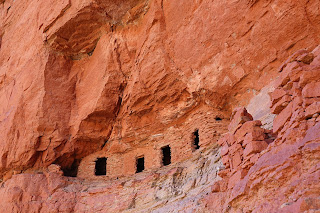
Our original plan had been to hike up Kwagunt Canyon on Day 3 and back to Nankoweap over the Kwagunt-Nankoweap Saddle on Day 4. At dinner the previous evening we'd agreed that this was perhaps too ambitious, and (since our backcountry permit had us over in Kwagunt Canyon on Night 3) settled instead on the plan of hiking over to Kwagunt Canyon along the river, then back the same way the following day—in effect cutting out the strenuous hike over the saddle while still staying legal with our permit. But lying in my tent that morning, the more I thought about this the more convinced I became that, from a health and safety point of view, the prudent thing to do would be to rest and recuperate. There were no howls of protest when I proposed this, and so the decision was made: we would make this an easy day, stay where we were, give our bodies plenty of horizontal time to recover; the day's hike would be to go down to the Colorado and visit the Granaries.

|
We began the day lazily, beginning the walk to the river around 10 and moseying down Nankoweap Creek slowly. There was a little water in the creek, but enough room in the wide and flat and sandy bed to make for a very pleasant walk (though at one point I tripped on a fallen yucca stem and landed open-handed on a clump of prickly pear, ruining a perfectly good glove in the process). We came across three or four people from rafting parties hiking upstream, but otherwise had the place to ourselves.

|

|

|

|
|
|

|

|

|
|
We reached the Granaries a little after 1, and after hanging out and enjoying the view for a while, headed back down to the creek and towards camp. The hike back was quicker, possibly motivated by the fading daylight. We reached camp just as the sun was setting. To my relief, I didn't see any citation for being camped in the wrong area. The rest of the evening was very pleasant and relaxed.

|
||
|
||

|
||

One odd thing we noticed was the behavior of a pair of birds—what I later found were black-headed grosbeaks—right by our campsite. As we moved around camp in the morning they was flitting around in the bushes, rustling the leaves loudly. When we returned to camp late that afternoon, many hours later, they were still rustling around that same little spot of ground, chirping loudly all the while. This behavior was puzzling—especially the incessant loud chirping, which drew attention to them and surely expended a good deal of energy in a place where food couldn't have been plentiful. Possibly we were camped too close to their nest?

The rest day eased our aches but didn't erase all the pain. Some time after dinner, as we were going about various chores around camp, I said something about how wonderful it was to have encountered so few other people. Nicole responded that that was because "only very few hikers would be stupid enough to come to this place." In mute wonder I gazed at the cliffs surrounding us soaring to the sky, luminous in the light of the setting sun.
Days 5 and 6: Nankoweap Creek to Trailhead
We were up by 4:30 and on the trail heading out of Nankoweap Creek a little after 6. Initially we hiked by the light of our headlamps, able to see only the small illuminated area in front of our feet. Little by little the bland darkness around us took shape: first the cliff and hills in the distance, silhouetted faintly across the faintly lightening sky; then, closer by, clots and blobs that slowly resolved into rocks and bushes and trees. By 7 we had our headlamps off. The air was cool and the hiking delightful. We reached the campsite above Tilted Mesa around mid-day. There was no particular enthusiasm among the group to keep hiking to the next plausible campsite at Marion Point, so after sitting around for a bit and having lunch, we set up camp. I lay in my tent, warmed by the mellow sunshine, and may have snoozed for a while.

|

|
Much to my astonishment, I found I had a cell signal. Somewhat guiltily I checked my email and the news headlines; the takeaway was that, as far as I could tell, the world had gotten by just fine in my absence.
As on the other days of this trip, the temperature dropped quickly once the sun dropped behind the cliffs. I stayed up a little bit watching the western sky change color. The crags and canyons below us slowly lost shape and faded into darkness. A very thin sliver of moon appeared above Mt. Hayden. I headed into my tent; the time was 5:30.

|

|
The plan the next morning was to hit the trail by 7, right around sunrise. When I began packing up my gear around 5:30, it was pitch dark with what seemed like a billion glittering jewels strewn across the sky; the familiar constellations were all there, old friends keeping me company as I went about my mundane chores.
Slowly, almost imperceptibly, the sky over to the east lightened and a faint horizon appeared. Gradually, very gradually and in utter still silence, shapes began to emerge from the undifferentiated darkness: mesas and buttes and gullies first; then, closer by, trees, rocks, and scrub bushes. Then, over a span of maybe fifteen minutes, the eastern sky exploded with purple and orange and red, lighting up a few thin wisps of cloud that hung low in the sky, like a celestial celebration of Holi. The sun finally popped above the horizon just as we shouldered our packs and began hiking. Suddenly there were shadows. The Supai cliffs above us glowed a luminous red-gold. Morning had broken, like the first morning.

|

|

|

|
The hiking was a lot easier at this point: our packs were a lot lighter (no more food, no extra water for dry camps), and the trail ambled along agreeably with none of the ferocious uphill slog of the previous day. I found myself hanging back, both to take pictures at my leisure but also to enjoy the silence and solitude of the Canyon on the last day of our trip.

|

|

|
|


No comments:
Post a Comment