In early March 2018, Tom and I spent 4½ days hiking the Boucher-Hermit loop (in on Boucher, out on Hermit Trail). Boucher is supposedly one of the hardest trails (if not
the hardest one) on the South Rim of the Grand Canyon: the Park Service's
trail description describes it as
|
"... tough, tedious traverses linked together by knee-destroying descents, with a section of exposed hand and toe climbing
thrown in for good measure."
|
Sure enough, the trail had its memorable stretches. But the reward for that challenge was peace and solitude and, as always, utterly gorgeous scenery. I thought it a fair deal.
The trip was thrown together on pretty short notice. Our original plan had been to hike in the Cedar Mesa area of Southern Utah, but in the end the combination of not quite enough hiking days (because of work obligations at my end) and concerns about availability of water (because of a dry winter) steered us away from the long drive up into Utah. The choice of Boucher Trail was almost an afterthought, and the availability of camping permits three days before our hike was a minor miracle. But it all worked out, making for a delightful hike overall.
Day 1
We headed out around 5am on Sunday March 4. Traffic on the interstate was light and the drive up uneventful. We were at the entrance to Grand Canyon National Park by 10:30am.

It had begun to snow lightly was we drove toward the Park Service's Backcountry Office to pick up our permits. This seemed ominous, considering that our first two nights were already expected to be pretty cold (the overnight low at the Rim was forecast to be 9°F, i.e., about –13°C; we'd be camped about 1,500 feet lower, at an elevation of about 5,400 feet, so probably not quite so cold but still likely to be well below freezing). My sleeping bag was an old 20°F bag whose "real" rating was likelier to be around 30°F---in other words, probably hopelessly inadequate. I had thrown in assorted additional layers to try and compensate, but of course always with an eye on total pack weight. The question of whether I'd packed enough insulation, or too much weight, eddied around the back of my mind as we drove to the trailhead.
We were on the trail a little before 11:30. The snow, which had stopped briefly, started up again: hard little pellets that the cold wind blew into our faces. My mind began conjuring up images of the snow melting and refreezing overnight into a glaze of ice on the "knee-destroying descents" coming up the next day. But my worries were unfounded: the snow soon stopped, leaving only a few isolated patches of gritty white stuff here and there along the trail, the wind died down, and the sun came out. The upper stretches of Hermit Trail,
neatly paved with painstakingly cut stones, made for a remarkably smooth hike down to just below Yuma Point. After a brief discussion of whether to keep going to a lower (and somewhat warmer) elevation, we decided against the possibility of having to deal with the hard parts of the descent when it got dark, and chose instead to stay where we were.
 |
| Water pockets in the rocks below Yuma Point |
The ranger at the Backcountry Office had mentioned water pockets in the rocks nearby. Expecting that the water would freeze overnight, we purified enough for the evening and the next day's hike. My water bladder had shown an small but unexpected damp patch when I had opened up my pack, and I had traced it to a tiny leak that looked like the result of old age. I made field repairs (Freesole and duct tape) while dinner rehydrated. Now I had another thing to worry about: were there other weak spots on the water bladder that might fail on the hike?
Before burrowing into my sleeping bag for the night (with
all my clothes on, even my rain jacket, and a down quilt on top), I put my water bladder, together with a bottle of water, near the foot of the sleeping bag, in the hope that that would keep them from freezing into lumps of ice overnight.
Day 2

It was still dark when I woke up. It was very tempting to just stay in the warm cocoon of my sleeping bag, but the day beckoned and couldn't put off for too long. It hadn't gotten as cold overnight as I had feared, though the low temperature of 22°F (-5°C) was the coldest I had ever camped in. Somewhat to my surprise, the cold didn't feel too bad as I went about my morning routine (though the water in the drinking tube on the water bladder froze in the short time it took to get my gear packed up, maybe because of its greater surface area relative to its volume).
 |
| Travertine Canyon |
We were on the trail by 7am. It wound its way along the Supai for a little while, then dived down into Travertine Canyon. The canyon narrowed quickly, its steep walls hemming the trail in on both sides. We soon came to the "crux"---a 15-foot near-vertical drop. There were plenty of hand- and foot-holds, and the downclimb didn't seem unduly difficult, even with our packs on---no worse than what one might expect a 15-foot downclimb to be. The trail continued to drop, steep and loose and rocky, and demanded complete and undivided focus; I can only imagine how challenging it would be if it was icy or obscured by snow.

|

|
| Tom moving through the crux point |
After descending through the Supai, the trail veered off to the left towards Whites Butte, contouring along above the Redwall layer. Compared to what we had just come through, this section of the trail seemed luxuriously mellow---it felt almost as though we were playing hooky!
Fortunately, the mellow stretch didn't last long enough for us to get used to it: after crossing the saddle below Whites Butte the trail plunged headlong down again, now through the Redwall. This stretch, which was incredibly steep and loose and rocky, seemed even more challenging than the descent through Travertine Canyon a little earlier. At one point Tom jokingly asked, "How far back did you lose the trail?", and the funny thing was that, considering what we were on, that would have been a very legitimate question in most other places. The loose stuff eased up once we were down past the Redwall layer, and a series of steep switchbacks led down to the junction with Tonto Trail. After a brief pause we turned left and headed downhill towards Boucher Creek, about half a mile away.
After setting up camp and relaxing for a little bit, we walked up Boucher Creek a short distance upstream. Boucher Canyon is very pretty and the early-spring afternoon was delightful.

|

|
 |
| The ruins of Louis Boucher's cabin |
|
 |
| fossil |
A special treat on the way back was Tom spotting a rock with a fossil imprint lying in the creek. Dinner was early and I think I was in my sleeping bag before the sky was dark!
Day 3
The plan for today was to hike downstream to the Colorado in the morning, then pack up and head up the Tonto for a dry camp somewhere in the Boucher use area. There was no particular rush, and after a leisurely breakfast we secured our food into our rat-sacks (mine out of sight inside an orange stuff-sack; Tom's visible through the rat-sack's steel-wire mesh), set them on the ground away from our tents, and zipped our tents down. A raven came out of nowhere just as we were about to leave, perched on a tree near our camp, and watched us as we headed down the trail.
 |
| Vishnu schist |
Heading down Boucher Creek felt quite different from our walk upstream the previous day. Upstream from our campsite, the creek flowed between walls of dark tan neatly-layered Tapeats sandstone; going downstream, we were flanked by cliffs of dark black Vishnu schist, unruly foliated cliffs that looked like they had been jammed down into the ground carelessly. The creek wound its way between them, descending gradually. It wasn't long before we were at the river. The roar of Boucher Rapids drowned out all other sounds. We sat by the river for a while, walled in by the crashing roar of the rapids, enjoying the solitude. Eventually, reluctantly, we headed back towards camp.
 |
| The Colorado River: Boucher Rapids |
|
 |
| Vishnu Schist cliffs across the river |
|
|
 |
| Raven raid aftermath |
We got the shock of our lives when we got back to camp. Shredded ziploc bags littered the campsite. Food was strewn carelessly everywhere. Tom's rat sack lay on the ground, a gaping hole torn in its steel wire mesh. The only possible culprits were the ravens! Bizarrely, my rat sack, which I had set down just a few feet away from Tom's when we set out for the river, was untouched (though a stuff sack containing my water filtering gear was ripped up and some of the contents scattered around). Tom did a quick inventory and found that he had lost about four meals worth of food. This could have been problematic, but I had some extra food I was happy to unload, and Tom did some redistribution, which made things work out overall. So, after a quick lunch, having cleaned up the mess as best we could, we packed up camp and headed out. (We found out later that the ravens had been able to tear through the steel-wire mesh in great part because the bags had been left on the ground, giving them more leverage. Apparently the thing to do is to leave bags hanging, e.g., from a tree, so that they don't have that leverage.)
 |
Travertine deposits:
Travertine Canyon |
|

|

|
The hike up the Tonto was pleasant, uneventful, meandering in the usual Tonto style. Our camping permit had us in the Boucher use area that night, so the plan was hike up close to the edge of the Boucher/Hermit use areas for a dry camp overnight, then hike down to Hermit Rapids the next day. Campable spots seemed scarce as we got closer to Hermit Canyon, and I was mentally debating between camping right on the narrow trail or pushing ahead and potentially ending up outside our permit area, when the terrain opened up and offered us some excellent campsites. It was only mid-afternoon, the sun was quite strong, and it seemed much too early to set up camp, so we lay around lazily and enjoyed the quiet beauty of the Canyon. The sharp tooth of the Temple of Ra watched over us from across the Colorado.
Day 4
We must have camped pretty close to the boundary of the Hermit use area: even allowing for a relaxed start in the morning, we were at Hermit Canyon by mid-morning. After several days of utter solitude, it felt a little strange to look down and see the line of tents at the campground, tiny little figures walking about, a line of hikers going down the trail on the other side of the canyon.
After we were down at the creek, we headed upstream a short distance. Hermit Canyon was absolutely lovely, with Hermit Creek burbling down the middle, hopping down a series of ledges in little waterfalls. We sat around for a while, enjoying the pleasant warmth of the early spring sunshine, had lunch, then eventually headed downstream to our permit-designated campsite down at Hermit Rapids.
 |
| Vishnu Schist with rose quartz intrusions |
The trail pretty much followed the stream down. It was a gentle gradient, pleasant and well-marked, flanked on either side with slabs of Vishnu schist mixed with beautiful streaks of orange and white quartz.

|

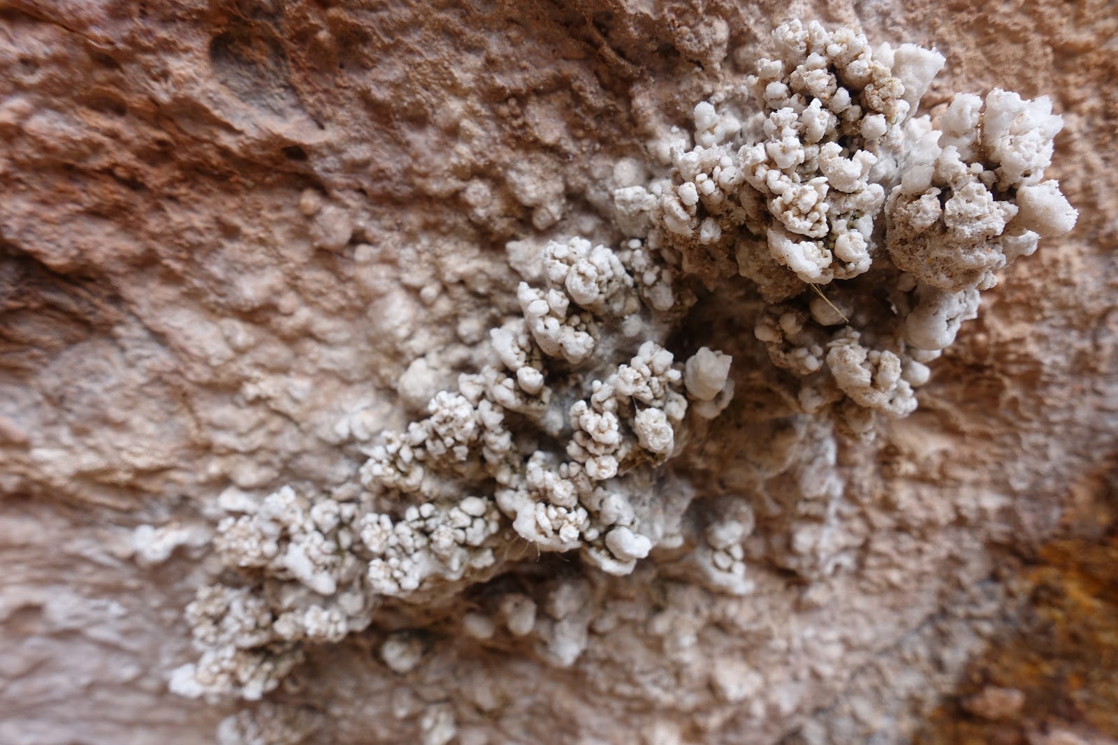
|
| Crystallized mineral deposits on the canyon wall below Hermit Spring |
The campground, when we got to it, was very different from what we had expected. Given the well-developed campground at Hermit Creek not far upstream, and given the popularity of Hermit Trail, we had expected something similar at Hermit Rapids as well; and initially we walked back and forth, puzzled, trying to figure out where the campsites might be. Eventually we approached a guy who was reading on a boulder by the river and asked for directions. It turned out that there was no developed campground and we could camp wherever we wanted. We chose a spot on a sandy stretch of beach some distance from the only other people we saw there. For all practical purposes, we had the place to ourselves.
Once our tents were set up, there was little to do but to sit back, relax, and enjoy the tail end of our stay in the Canyon. It made little sense to haul our remaining alcohol all the way back up to the rim, so naturally we worked on lightening that load. And of course we solved all the problems of the world (the alcohol helped).
I didn't bother putting on the rainfly on my tent that night. The sky was a glittering field of stars, rotating silently above me each time I opened my eyes.
Day 5
The hike out: 9.7 miles to cover, with an elevation gain of a little over 4,300 feet. We started early: up at 4:30; on the trail by 6:30, as soon as we could see where we were walking. The early morning air, with just a slight hint of chill, was delightful to hike in. We paused briefly at Hermit Creek, a little ways below the campground, to pick up some water, then headed up to the Tonto.
 |
Tom going up
Cathedral Stairs |
The Tonto contoured along for a while as it headed east, then Hermit Trail struck out to the right, heading generally southwards up towards the Rim. It started climbing almost immediately, a long unrelenting uphill stretch culminating in the Cathedral Stairs section that switchbacks steeply through the Redwall layer. The trail "leveled out" after that, settling into a long , tedious traverse that contoured along the Supai and seemed to just go on and on and on. But the solitude of the trail (which we had pretty much to ourselves), the perfect weather, and the stunning views made for a memorable experience.

|

|

|
| Scenes from the traverse across the Supai |
 |
| The resthouse at Santa Maria Spring |
Eventually we reached Santa Maria Spring, with its cute little rest house. At 5,000 feet, we had now come up 2,700 feet from where we had started by the Colorado that morning; the trailhead was 2.2 miles and 1,640 vertical feet away. The trail steepened quite a bit on that last leg, and together with the thinner air at the higher elevation, slowed us down. This last stretch was also quite a bit more crowded, almost entirely all day hikers. We reached the trailhead around 4pm.
Postscript
I had wanted to hike Boucher for a long time. Everything I'd read about the trail talked about its difficulty–its "
knee-destroying descents"–to the point where its reputation as The Hardest Trail on the South Rim became a near-mythic thing for me. I got my gear ready in a state of eager trepidation.
An email from Tom a couple of days before the trip helped put it in perspective:
|
"The Sky Terrain map shows the "descent into slot-like Travertine Canyon" that I mentioned yesterday as a double-black-diamond, along with six other stretches with single BDs [black diamonds] scattered along the way, mostly for steep sections, exposure, or rockfalls. Meh. :-)" |
That turned out to be a pretty accurate assessment: there was maybe half a day worth of hiking that really needed a total and complete focus on each step we were taking, but other than that it was really just a lovely, lovely hike.
 It had begun to snow lightly was we drove toward the Park Service's Backcountry Office to pick up our permits. This seemed ominous, considering that our first two nights were already expected to be pretty cold (the overnight low at the Rim was forecast to be 9°F, i.e., about –13°C; we'd be camped about 1,500 feet lower, at an elevation of about 5,400 feet, so probably not quite so cold but still likely to be well below freezing). My sleeping bag was an old 20°F bag whose "real" rating was likelier to be around 30°F---in other words, probably hopelessly inadequate. I had thrown in assorted additional layers to try and compensate, but of course always with an eye on total pack weight. The question of whether I'd packed enough insulation, or too much weight, eddied around the back of my mind as we drove to the trailhead.


 It was still dark when I woke up. It was very tempting to just stay in the warm cocoon of my sleeping bag, but the day beckoned and couldn't put off for too long. It hadn't gotten as cold overnight as I had feared, though the low temperature of 22°F (-5°C) was the coldest I had ever camped in. Somewhat to my surprise, the cold didn't feel too bad as I went about my morning routine (though the water in the drinking tube on the water bladder froze in the short time it took to get my gear packed up, maybe because of its greater surface area relative to its volume).