In mid-October 2015 we (my friends Herman and Nancy, and Tom, and I) spent a week hiking the Tanner and Beamer trails to the Little Colorado (LC) and back. I had heard a lot about, and always wanted to see, the turquoise waters of the Little Colorado flowing into and mixing with the dark green waters of the Colorado, and Tom thought we'd have enough time on this trip to hike up the Little Colorado to the Sipapu ("place of emergence"), which is sacred to the Hopis. As it turned out (and as our friend Larry had correctly predicted), an exceptionally strong El Niño season didn't lend itself to clear turquoise LC waters. But the hike was memorable regardless, with much to look back on fondly. Also, character was built.
(Nancy had been suffering from a painful case of plantar fasciitis in the weeks leading up to the hike, and even just a few days before the hike, her ability to go on the hike—and, therefore, Herman's as well—had been in doubt. That she ended up hiking the entire distance, over some very challenging terrain, speaks to an amazing level of determination and fortitude.)
Day 0. We drove up from Tucson on Fri Oct 9; since this was a work day, we left Tucson late in the afternoon. It was long after dark when we pulled onto a dirt road on National Forest land near the East Entrance to GCNP, found some flat space, made camp quickly, and turned in for the night.
Day 1 [Oct 10]. After a huge breakfast of eggs and bacon that Herman whipped up, we headed over to into GCNP. We had decided to spend our first night in the Canyon at a flat spot just below the Redwall and get to the Colorado the morning of the second day. Breaking up the hike this way meant that we wouldn't have to hurry and could set a comfortable pace; the downside was that our packs would be heavier because of the extra water we'd need for the dry camp the first night.
Since we wouldn't be travelling too far this day—roughly five miles or so—we didn't have to rush to start the hike, so we took a brief detour via the Desert View Watchtower and were on the trail shortly after 8. The trail descends steeply from the rim down to Seventyfive Mile Canyon saddle, dropping 1,700 feet in just under two miles in what the National Park Service's Tanner Trail description refers to as "notably insecure hiking". Between the weight of our packs, and the issues with Nancy's feet, we took this section of the hike carefully and got to the saddle around 10am.
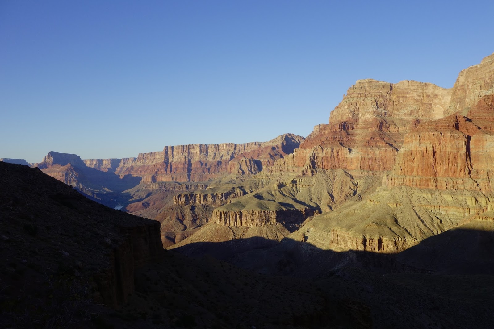
The trail leveled out for the next three miles, contouring along the base of Escalante and Cardenas Buttes until we got to the top of the Redwall. The Park Service trail description calls the Redwall descent "nasty—steep and loose", but it didn't seem quite that bad to me, either on the descent or on the ascent. We made our way down carefully and uneventfully and some time around 3-ish got to the flat area where we'd be camping that night. It felt good to take our packs off, but the sun beating down on us was pretty hot and there wasn't much in the way of shade except for a few scraggly bushes. Beggars, choosers, etc.: we made do with what shade we could find and waited for the sun to sink lower. We may have broken into our Drambuie—I don't remember (which perhaps is suggestive in itself).
Day 2. After breakfast we broke camp and headed down towards the river. It wasn't all that far to the river (maybe 4 miles), and hiking in the early-morning cool meant we didn't need a whole lot of water (we'd refill at the river), so our packs were quite a bit lighter than they had been the previous morning, and the hiking was very pleasant. Except for a steep and rocky section right below our campsite, the trail wasn't too bad. We reached the river around 11:30.
Our first surprise: we found the Colorado running brown and thick with mud and silt. This was a bit of an inconvenience when pumping (i.e., purifying) water because of the frequent need to dismantle and unclog our water filters, but we didn't think too much of it beyond that. We must have figured, or hoped, that the river would clear up as we headed upstream. Little did we know how forlorn a hope this would turn out to be.
By early afternoon, having had lunch and taken on water, we left Tanner and headed east along the Beamer Trail for Palisades Wash about three miles away. The trail wasn't too challenging terrain-wise, but the sun was bright and hard above our heads and the heat was enervating. By the time we arrived at Palisades, around 4 pm, we were pretty beat.
A group of rafters had pulled in just before we arrived and were setting up camp near the river. They offered us cold beer, which tasted absolutely delicious after the heat of the hike. More importantly, we found out that the Colorado was running muddy all the way up to the Little Colorado—in fact, the LC was the source of all the mud! Visions of a turquoise-blue LC evaporated.
More problematic were the implications of the silt for purifying water. Earlier in the day, at Tanner, I was getting maybe ½ – ⅓ quart of water from my pump before the filter clogged up and needed to be cleaned, which meant that getting a day's worth of water (hike plus meals, about 5–6 qts) was slow, tiring, and frustrating; Herman's pump couldn't be field-cleaned, but needed to be back-flushed with clean water, which obviously posed a problem; and Tom had a steri-pen, whose effectiveness was limited in cloudy water. We had buckets that we could use to let the silt settle out—this made the pumping easier, but also meant having to wait for several hours before we could actually pump water. To compound matters, we were going through a mini heat-wave the week of the hike: the official "in the shade" temperatures in Tucson—roughly comparable to (maybe slightly cooler than) the bottom of the Canyon—for the week were in the 90s; and on the sun-exposed trails we were hiking, our thermometers read over 100°F even fairly late in the day. The heat, of course, meant we'd need a lot of water. This combination of circumstances was worrisome and weighed on us that night.
And yet. The Grand Canyon is a magical place, and whatever worries we may have had, about heat or silt or whatever, faded away before the gorgeous vistas all around us. As the day gradually faded, the cliffs glowed in the late-afternoon light that changed from minute to minute. It made you wish for a pause button to the day, so you could take your time to admire and enjoy the harsh loveliness all around before it faded away into the evening.
But reality is stubborn, and demanded to be appeased once the magic of sunset had faded. And so, in preparation for the next day's hike, we spent several hours before going to bed pumping water from our buckets by headlamp-light.
Day 3. We were up before dawn in order to hit the trail early and cover as much distance as we could before it got too warm. Our goal was to hike about six miles to a campsite near the confluence of the Colorado and LC (the area immediately around the confluence is closed to overnight camping).
The trail headed north from our campsite, crossing Palisades Wash and then climbing about 300 feet to the top of the Tapeats and following the river all the way to the LC. There was a long section where the trail was very narrow and skirted the very edge of the cliffs; the exposure, with a sheer drop all the way down to the river, focused one's mind. Eventually the exposure dissipated, but then the trail began going in and out of side drainages in order to follow the contour, which got old pretty quickly: we could see where we needed to be on the other side of the drainage, not far away, but we had to do this detour to get there. It wasn't as bad as some of the detours on the Tonto, but there were a lot of them (Herman counted upwards of two dozen from his previous visit to this area) and they added quite a bit to the distance we had to cover.
We got to the campsite in the early afternoon: a sandy stretch of beach a little ways downstream from the confluence. It was hot, and we were tired, so we found what shade we could and hid. Drambuie levels dropped. A small rafting party went by, one of the rafters topless. The day went by slowly and lazily. By now we had grown accustomed (and resigned) to our water-pumping routine—haul as much water as possible into a bucket or container, wait several hours for the silt to settle, then pump the clear water on top—and so were feeling a lot less stressed about it, and the evening was pleasant and relaxed.
Day 4. The plan for the day was to day-hike to and up the Little Colorado. Our campsite wasn't far from the confluence, so it didn't take us long to get there. From our vantage point a couple of hundred feet above the two rivers, the view of the mixing of their waters was fascinating, though not quite what we had originally hoped for: the LC, coming in from the east running thick and brown and silty, colliding with the clear green of the Colorado and turning everything into a muddy mess.
When planning this hike, we had intended to go up the LC to the Sipapu. That would necessarily involve a fair amount of wading in the LC, which now seemed iffy because of the fast-flowing water where we couldn't see where we were stepping. After some discussion, we decided to abandon our plans to get to the Sipapu and just hike up the canyon instead.
The wander up the canyon of the LC was pleasant, if warm. We found Ben Beamer's cabin, dating from around 1890, under an overhang close to the confluence. Some time later, to our surprise, we came across a bunch of telemetry gear perched above the LC, possibly to monitor its level and/or flow—completely unexpected this far out in the wilderness.
It got pretty hot pretty quickly as the morning wore on, and there wasn't much shade on the trail. In an attempt to cool down, we took to wetting our shirts and bandannas in the river—a sopping wet shirt would last for maybe half an hour before drying out, and we'd repeat the process. After a few rounds of this my shirt was so stiff from leavings of the evaporated river water that it felt like it had been starched!
On the way back we happened upon a faint trail that paralleled the LC, which we'd missed on the way up and which made the hike back a little bit easier. The prospect of spending the afternoon on a sandy beach with very little shade wasn't too appealing, and Tom and I ended up hanging out in the shade of a cliff for several hours until the day cooled off a little.
The entire week of our trip had been fiercely hot, with afternoon temperatures in the 90s in the shade and well over 100°F on the trail, which offered very little shade. This limited the amount of enjoyable hiking time. It also increased the amount of water we needed, and pumping/purifying the thick silty water was no fun. After discussing our options, therefore, we reluctantly decided to end the trip a day earlier than planned.
(Nancy had been suffering from a painful case of plantar fasciitis in the weeks leading up to the hike, and even just a few days before the hike, her ability to go on the hike—and, therefore, Herman's as well—had been in doubt. That she ended up hiking the entire distance, over some very challenging terrain, speaks to an amazing level of determination and fortitude.)
Day 0. We drove up from Tucson on Fri Oct 9; since this was a work day, we left Tucson late in the afternoon. It was long after dark when we pulled onto a dirt road on National Forest land near the East Entrance to GCNP, found some flat space, made camp quickly, and turned in for the night.
 |
| Herman making breakfast |
Since we wouldn't be travelling too far this day—roughly five miles or so—we didn't have to rush to start the hike, so we took a brief detour via the Desert View Watchtower and were on the trail shortly after 8. The trail descends steeply from the rim down to Seventyfive Mile Canyon saddle, dropping 1,700 feet in just under two miles in what the National Park Service's Tanner Trail description refers to as "notably insecure hiking". Between the weight of our packs, and the issues with Nancy's feet, we took this section of the hike carefully and got to the saddle around 10am.
 |
 |
| Seventyfive Mile Canyon | Stegosaurus Rocks |
 |
| View from the top of the Redwall |
 |
|
 |
 |
| Views from our campsite below the Redwall | |
Day 2. After breakfast we broke camp and headed down towards the river. It wasn't all that far to the river (maybe 4 miles), and hiking in the early-morning cool meant we didn't need a whole lot of water (we'd refill at the river), so our packs were quite a bit lighter than they had been the previous morning, and the hiking was very pleasant. Except for a steep and rocky section right below our campsite, the trail wasn't too bad. We reached the river around 11:30.
 |
 |
| Views on the hike down to the river | |
 |
 |
| The Colorado running muddy at Tanner | |
A group of rafters had pulled in just before we arrived and were setting up camp near the river. They offered us cold beer, which tasted absolutely delicious after the heat of the hike. More importantly, we found out that the Colorado was running muddy all the way up to the Little Colorado—in fact, the LC was the source of all the mud! Visions of a turquoise-blue LC evaporated.
More problematic were the implications of the silt for purifying water. Earlier in the day, at Tanner, I was getting maybe ½ – ⅓ quart of water from my pump before the filter clogged up and needed to be cleaned, which meant that getting a day's worth of water (hike plus meals, about 5–6 qts) was slow, tiring, and frustrating; Herman's pump couldn't be field-cleaned, but needed to be back-flushed with clean water, which obviously posed a problem; and Tom had a steri-pen, whose effectiveness was limited in cloudy water. We had buckets that we could use to let the silt settle out—this made the pumping easier, but also meant having to wait for several hours before we could actually pump water. To compound matters, we were going through a mini heat-wave the week of the hike: the official "in the shade" temperatures in Tucson—roughly comparable to (maybe slightly cooler than) the bottom of the Canyon—for the week were in the 90s; and on the sun-exposed trails we were hiking, our thermometers read over 100°F even fairly late in the day. The heat, of course, meant we'd need a lot of water. This combination of circumstances was worrisome and weighed on us that night.
And yet. The Grand Canyon is a magical place, and whatever worries we may have had, about heat or silt or whatever, faded away before the gorgeous vistas all around us. As the day gradually faded, the cliffs glowed in the late-afternoon light that changed from minute to minute. It made you wish for a pause button to the day, so you could take your time to admire and enjoy the harsh loveliness all around before it faded away into the evening.
 |
 |
 |
 |
| Views from Palisades Beach | |
Day 3. We were up before dawn in order to hit the trail early and cover as much distance as we could before it got too warm. Our goal was to hike about six miles to a campsite near the confluence of the Colorado and LC (the area immediately around the confluence is closed to overnight camping).
 |
 |
| The narrow trail at the edge of the cliffs | The long drop |
The trail headed north from our campsite, crossing Palisades Wash and then climbing about 300 feet to the top of the Tapeats and following the river all the way to the LC. There was a long section where the trail was very narrow and skirted the very edge of the cliffs; the exposure, with a sheer drop all the way down to the river, focused one's mind. Eventually the exposure dissipated, but then the trail began going in and out of side drainages in order to follow the contour, which got old pretty quickly: we could see where we needed to be on the other side of the drainage, not far away, but we had to do this detour to get there. It wasn't as bad as some of the detours on the Tonto, but there were a lot of them (Herman counted upwards of two dozen from his previous visit to this area) and they added quite a bit to the distance we had to cover.
We got to the campsite in the early afternoon: a sandy stretch of beach a little ways downstream from the confluence. It was hot, and we were tired, so we found what shade we could and hid. Drambuie levels dropped. A small rafting party went by, one of the rafters topless. The day went by slowly and lazily. By now we had grown accustomed (and resigned) to our water-pumping routine—haul as much water as possible into a bucket or container, wait several hours for the silt to settle, then pump the clear water on top—and so were feeling a lot less stressed about it, and the evening was pleasant and relaxed.
 |
 |
| Right above our campsite: Cape Solitude | |
 |
|
| Looking upstream from our campsite | |
 |
| The confluence. The LC is the muddy stream coming in from bottom right; the Colorado is the clear green water coming in from the middle of the picture. |
 |
 |
 |
|
| The Little Colorado near the confluence | |
The wander up the canyon of the LC was pleasant, if warm. We found Ben Beamer's cabin, dating from around 1890, under an overhang close to the confluence. Some time later, to our surprise, we came across a bunch of telemetry gear perched above the LC, possibly to monitor its level and/or flow—completely unexpected this far out in the wilderness.
 |
 |
| Beamer's Cabin | |
 |
 Seeking shade under a rock ledge |
| Tom checking out some telemetry gear | |
 |
 |
 |
|
 |
|
It got pretty hot pretty quickly as the morning wore on, and there wasn't much shade on the trail. In an attempt to cool down, we took to wetting our shirts and bandannas in the river—a sopping wet shirt would last for maybe half an hour before drying out, and we'd repeat the process. After a few rounds of this my shirt was so stiff from leavings of the evaporated river water that it felt like it had been starched!
On the way back we happened upon a faint trail that paralleled the LC, which we'd missed on the way up and which made the hike back a little bit easier. The prospect of spending the afternoon on a sandy beach with very little shade wasn't too appealing, and Tom and I ended up hanging out in the shade of a cliff for several hours until the day cooled off a little.
 |
| Back at camp |
Day 5. We woke up early and, after a quick breakfast, broke camp.
The early mornings are delightful. The air is cool from the night and the bottom of the Canyon stays shady well into mid-morning. Hiking is a joy: there's no hint of the heat that will devour you later in the day—though you know it's there, you can feel it in the crispness of the shirt that you starched in the river the day before. I turned south towards Tanner with a mixture of regret and relief.

Shortly after we got on the trail, Tom spotted two bighorn sheep on the other side of the river. They stood and watched us for a few minutes as we watched them. A little later, we were startled by the loud yipping of a pack of coyotes (magnified by echoes off the cliffs above us). They couldn't have been too far from us. Tom thought that maybe one of them had spotted prey and was alerting the others; I hoped they weren't looking at us.
 |
 |
| Entrance to Tanner's mine |
The sun was pretty high in the sky by the time we got to Palisades Wash. After lunch in the shade of some mesquite trees, we detoured to the entrance to Tanner's old mine at the foot of the cliffs above the wash before getting back on the trail. We made camp for the night just north of Espejo Creek, roughly a mile south of Palisades Wash and about 7½ miles from our campsite near the LC.
Day 6. The goal today was to hike over to Tanner Beach (about 2 miles), replenish our water, then head up Tanner Trail and camp above the Redwall (about 5½ miles, 3000 feet elevation gain).

The hike to Tanner was in shade and quite pleasant. Once we began climbing out of Tanner, though, we were in full sun and it began to warm up quickly. The combination of the heat, the weight of extra water for the upcoming dry camp atop the Redwall, and the unrelenting uphill grade, made for slow going (it was, literally, nauseating; salt tablets helped). After a while, we took cover under a small rock ledge and just waited out the next few hours of blistering heat. We eventually made our way up the Redwall and made camp at a wide flat spot looking down over the Canyon. The view, as the sun sank low and the light turned golden, was breathtaking: it made the day's slog well worth it.

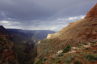
Day 7. The last day of the trip. It was a cloudy morning and it looked like it could be raining farther out over the Canyon. The clouds made for cool and pleasant hiking. There was a beautiful rainbow arcing across the sky at Seventyfive Mile Canyon saddle—a farewell gift from the Canyon after a hard, hot week.
As we climbed out above the Coconino sandstone on the upper section of the trail we were drenched by a brief cloudburst. We were back at the trailhead by lunchtime.
Postscript. This trip description mentions "hot" a lot—I hope that doesn't come across as whiny, it isn't intended to be. The National Park Service's Tanner Trail description says
It would be easy to get the impression that the trip was a disappointment; it was not. Certainly there were challenges—the heat, the lack of shade, the silty brown water—but mostly these were problems to work around rather than walls to crash against. And once we'd figured out the work-arounds, we had the solitude, the silence, the stunning vistas, the cliffs glowing golden in the light of the setting sun. I have yet to be disappointed by the Grand Canyon.
There were just two (related) things that we couldn't work around: the LC was missing its fabled turquoise blue waters; and we didn't make it to the Sipapu. This simply means we'll have to go back in again. I'm looking forward to that hike already!
Finally, I'd mentioned at the beginning that Nancy almost didn't come on this trip because of plantar fasciitis. Amazingly, she hiked the entirety of the trip without any issues; she said later that the hike cured the problem and the pain went away! We'll attribute this miracle to Saint Harvey, patron saint of Grand Canyon hikers.

The hike to Tanner was in shade and quite pleasant. Once we began climbing out of Tanner, though, we were in full sun and it began to warm up quickly. The combination of the heat, the weight of extra water for the upcoming dry camp atop the Redwall, and the unrelenting uphill grade, made for slow going (it was, literally, nauseating; salt tablets helped). After a while, we took cover under a small rock ledge and just waited out the next few hours of blistering heat. We eventually made our way up the Redwall and made camp at a wide flat spot looking down over the Canyon. The view, as the sun sank low and the light turned golden, was breathtaking: it made the day's slog well worth it.

Day 7. The last day of the trip. It was a cloudy morning and it looked like it could be raining farther out over the Canyon. The clouds made for cool and pleasant hiking. There was a beautiful rainbow arcing across the sky at Seventyfive Mile Canyon saddle—a farewell gift from the Canyon after a hard, hot week.

As we climbed out above the Coconino sandstone on the upper section of the trail we were drenched by a brief cloudburst. We were back at the trailhead by lunchtime.
Postscript. This trip description mentions "hot" a lot—I hope that doesn't come across as whiny, it isn't intended to be. The National Park Service's Tanner Trail description says
"The Grand Canyon in general is infamous for summer heat and the Tanner Trail is specifically noted as being unusually hot. The wide open nature of this part of the canyon means the summer sun comes up early and sets late. No water means no vegetation, and that means no shade. River runners call this part of the Grand Canyon "Furnace Flats". Avoid this trail during hot weather."I can attest to the truth of this.
It would be easy to get the impression that the trip was a disappointment; it was not. Certainly there were challenges—the heat, the lack of shade, the silty brown water—but mostly these were problems to work around rather than walls to crash against. And once we'd figured out the work-arounds, we had the solitude, the silence, the stunning vistas, the cliffs glowing golden in the light of the setting sun. I have yet to be disappointed by the Grand Canyon.
There were just two (related) things that we couldn't work around: the LC was missing its fabled turquoise blue waters; and we didn't make it to the Sipapu. This simply means we'll have to go back in again. I'm looking forward to that hike already!
Finally, I'd mentioned at the beginning that Nancy almost didn't come on this trip because of plantar fasciitis. Amazingly, she hiked the entirety of the trip without any issues; she said later that the hike cured the problem and the pain went away! We'll attribute this miracle to Saint Harvey, patron saint of Grand Canyon hikers.


Great and accurate description of this particular hike. You have a gift for accurate narrative. I have done this hike Beamer trail hike twice (Tanner multiple times)--only a river trip allowed me to see the Little Colorado River turquoise blue.
ReplyDelete