Early in Nov. 2016, Tom and I spent six days backpacking and hiking in SE Utah, in and around
Grand Gulch and
Butler Wash, near
Cedar Mesa. We had visited the area the previous year, on the way back to Arizona from our Canadian Rockies hike, found a gorgeous landscape with an amazing richness of Ancestral Puebloan ruins, and promised to come back to explore more deeply. This was that trip.
I met Tom in Flagstaff on the morning of Nov. 5. The weather forecast was for clear, sunny, and mild conditions all week, and we'd timed it to escape the robocalls and election hysteria that would crescendo the following week. We were in a good mood as we headed north-east through the Navajo reservation. But the towering banks of gray clouds stacked over the horizon seemed only to thicken and darken ominously as we wiggled through
Moki Dugway and approached Cedar Mesa.
(A small digression on transportation logistics. We had come up in one vehicle, and the entrance on our planned route was different from our exit point, which meant an 8-to-10 mile walk along a road to get from one to the other. We chose to park at the exit point at Bullet Canyon trailhead, then walk to the entry point at Kane Gulch.)
I. Backpacking

It had begun to drizzle by the time we pulled up at the Bullet Canyon trailhead, which meant that our initial walk to Kane Gulch would be a little damper than planned. Tom, ever the optimist, pointed out that the weather forecast was for the rest of the week to be clear and beautiful; my inner pessimist was sure that the raindrops as we began walking were a bad omen. But things soon began looking up: a passing motorist stopped and gave us a ride to Kane Gulch, and, as we began hiking, the drizzle gradually lessened and eventually stopped. We hiked in about a mile and set up camp under an overhang.
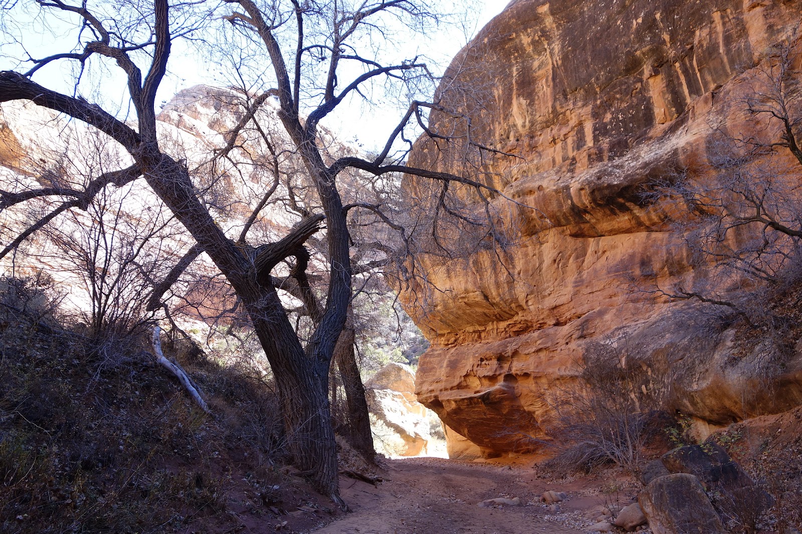
From Kane Gulch, the trail to the junction with Grand Gulch dropped a mellow 500-ish feet over a distance of about 3½ miles of gorgeous Utah slickrock landscape. It ran mostly along the bottom of the gulch, soft and sandy and pleasant to walk on; very often it was covered in leaf litter, from the cottonwoods growing alongside, that hushed our footsteps and made for a quiet and contemplative hike. The air was nice and cool, the sun pleasantly warm. The hike was delightful.
There was just one thing that seemed just slightly odd at the time—although more in retrospect now than it was at the time. There wasn't much in the way of flowing water along the bottom of the gulch. While there were many good-sized pools of standing water, these were often inky black and full of decaying leaf litter (if this had been a movie, this would've been a good time cue ominous music). But we knew about several "reliable" springs along our route, so we just wrinkled our noses and moved on.
We reached the junction of Kane Gulch and Grand Gulch mid-morning and went looking for Junction Ruin, which was less than a quarter mile from the junction. We saw some ruins above us as we walked along the trail, but didn't realize that they were what we were looking for, and hiked past them for nearly a mile before heading back. The ruins themselves (once we realized, pretty much accidentally, where they were) were very impressive. There were three distinct levels of structures, with many rooms at each level (dozens, according to the description in the papers BLM kept at the site in an ammo box), the topmost level high above us and reachable only by a precarious log ladder. Several of the structures had been somewhat restored, but not overly obtrusively, and gave a good sense of what the place may have looked like originally.
Later, hiking downstream to Todie Canyon, we got our first surprise: Todie Spring, the first of three "reliable" springs along the route, was nowhere to be found! The best we were able to do, after searching around for a bit, were a couple of pools of foul-smelling stagnant water full of rotting leaves: not very appetizing, but better than no water. We used Tom's syringe to suck water out of the pool, to avoid disturbing the muck at the bottom, and this slowed down the whole process. More than the delay, though, what was sobering were the potential implications of a "reliable" spring going dry.
Shortly afterwards, to our happy surprise, we came upon a small pool of water that was far enough from the trees to not have leaves rotting in it. We dumped the smelly water we'd pumped just a little while ago and filled up on the clean water from this pool. Once again, syringe-to-bucket to avoid stirring up muck, then pump the water out of the bucket: quite a bit slower than just pumping water out of a stream or river. I think water purification at Todie Canyon set us back a couple of hours altogether!
Other than the missing spring, the hike continued to delight. The trail meandered downstream gently along Grand Gulch, mostly along the soft sand of the creek-bed but stepping onto the bank here and there to avoid a muddy stretch or brushy spot (the sand was kind to the feet most of the time, but there were a few longish stretches of deep soft sand that we were happy to get out of). We dropped our packs at a nice flat sandy spot beside a huge gnarly old cottonwood tree on the creek bank, half a mile above Split Level Ruin, and headed down to admire the ruins while we still had some light; Tom was so excited he was almost buzzing. We returned to camp as the light began to fail. The temperature began to drop quickly after sundown, and we were both tired, so we didn't stay up for long after dinner.
We made a beeline for Split Level Ruins after breaking camp the next morning. These were a cluster of structures under an overhang on a small hillside a few dozen feet above the level of the trail, spanning, as the name suggests, two levels. There were several smaller storage structures off to a side nearby; the midden—essentially the prehistoric settlement's garbage dump, now considered invaluable for archaeological research—lay cordoned off under the slope below the buildings. The entire collection of ruins, lit up by the morning sunlight, was even more impressive than it had seemed in the fading light of the previous evening. Especially fascinating to me was the debris field of ancient corn cobs and pieces of broken pottery lying around below the midden. I think we must have spent well over an hour wandering around examining the ruins.
A little way down the hike we came to
Sheiks Canyon, which held the Green Mask and Yellow House Ruins and also the second of our three reliable springs. For reasons unimportant for this story, Tom and I wandered off on our explorations separately, leading to something like a game of Marco Polo up and down the canyon. Eventually we ran into each other, went up to see the ruins, and noticed the panel upon panel of dazzling pictographs—including the famous Green Mask pictograph—decorating the limestone wall above our heads.
 |
| Happy campers: At Grand Gulch-Bullet Canyon junction |
We didn't take on any water at Sheiks Spring, despite the good flow of clean water, because the next reliable water source, a spring at the junction with Bullet Canyon, was less than two miles downstream. But once again, when we got there the spring was nowhere to be found. We had enough water to tide us through to the next morning, but the bigger picture was disturbing: two of the three springs considered reliable had been dry, which didn't bode well for the smaller (and presumably less reliable) springs we'd have further downstream. There was supposed to be another good spring a couple of miles up Bullet Canyon not far from Jailhouse Ruin (which we had visited the previous year), but it was late in the day and we had enough water for the evening, so we decided to go look for it the next day.
Our optimism was misplaced. We did find water, but—like most of the pools we had seen on the hike—it was stagnant and smelly, choked with rotting leaves: enough that we wanted to see if we could find anything better. But first we checked out Perfect Kiva, which we had missed by just a tiny bit the last time we were here.
Perfect Kiva, and the structures near it, were impressive, but had quite obviously been restored (for example, the rungs on the ladder into Perfect Kiva were bolted on). A highlight for me was climbing down into Perfect Kiva, which gave a sense of what it must have been like originally; the obvious restoration detracted slightly from the experience, but only very slightly.
On our way up to Perfect Kiva, Tom spotted a dark streak across some rocks from us. When we went to check it out afterwards we found several puddles of clean water that must have added up to two or three gallons of water. Elated, we got down to the now-familiar syringe ritual to pull water from the puddles without disturbing the mud at the bottom. We had purified about three quarts each when, within a few minutes of each other, our purification devices failed—Tom's steripen stopped with an error message, and the piston rod inside my pump broke, rendering it unusable. Oops.
This, of course, changed the situation completely: suddenly, we had no way to purify water even if we could find it. (We did have some chlorine tablets as emergency backup, but not enough for two people for the remaining three days of our trip.) So, with great regret, we bailed out of the backpack, hiking back up Bullet Canyon to where Tom's truck was parked.
In summary, we'd had three days of backpacking: a little ways into Kane Gulch (day 0, night 1); down Kane Gulch to Grand Gulch above Split Level Ruin (day 1, night 2); down Grand Gulch to the junction with Bullet Canyon (day 2, night 3); and out Bullet Canyon (day 3). Not too bad, but a lot less than what we'd planned.
II. Not backpacking
Once we got over the independent and near-simultaneous failures of two different water purification systems, our suddenly-revised plan was to pick up water from the nearest town, then explore what we could over the three days we had left via day-hikes. We spent one day hiking down Government Canyon to Big Man Panel, then basically worked our way south down Butler Wash visiting various different points of interest: Fish Mouth Cave, Procession Panel, and finally all the way down to the San Juan river.
The drive down the dirt road paralleling Butler Wash was ... interesting. The road was not in very good shape, and if it hadn't been for Tom's high-clearance truck, plus a lot of very careful driving, we would never have gotten through. Once we got to the trailhead, though the hiking was delightful: the weather was calm and cool and wonderful, the terrain was mellow, and the lightness of the packs on our backs surprisingly (given our disappointment at having to abort the backpack) pleasant.
We saw quite a few ruins on these hikes, but mostly we saw art: pictographs and petroglyphs. There were several that were jaw-droppingly stunning. I don't think I can say anything that would do them anything close to justice, so I'll just put up some pictures and note that these were created many many many hundreds of years ago by people who had only relatively primitive tools at their disposal.

|

|
| Big Man Panel |

|

|
| Pollys Canyon |

|

|
| Fish Mouth Cave |
 |
|
Monarch Cave Ruin |
 |
|
Procession Panel |
 |
|
View from the top of Comb Ridge |

|

|

|
| Butler Wash: Petroglyphs near the San Juan River |
More pictures are available
here.
III. Looking back

What made this trip memorable was, of course, the abundance of ancient ruins. That was what we'd gone up for to begin with, but even then the reality far exceeded my expectations. It was amazing what the ancient Indians had been able to accomplish given the primitive tools they had. Of all the things we saw, the ones that spoke to me the most strongly and directly were the hand-prints left behind on the rock walls by these anonymous artists: a little personal greeting, as it were, from a long time ago. I found myself wondering: Would (could) anything I create last as long?
It was disappointing, of course, that we'd had to end our backpack early. On the other hand, given the circumstances, things had worked out remarkably well in that we were able to hike out without any issues and continue our explorations via day hikes. More sobering was the fact that two of the three "reliable" springs we had been counting on were dry. I couldn't help but consider the implications for the animals that relied on those springs.
by Craig Childs, at a used book store in Austin, TX. This book talks about the prehistory of the Southwest, intermingled with the author's own experiences in exploring that prehistory, in gloriously lyrical and evocative language. I wish I'd read this book before our hike.
 It had begun to drizzle by the time we pulled up at the Bullet Canyon trailhead, which meant that our initial walk to Kane Gulch would be a little damper than planned. Tom, ever the optimist, pointed out that the weather forecast was for the rest of the week to be clear and beautiful; my inner pessimist was sure that the raindrops as we began walking were a bad omen. But things soon began looking up: a passing motorist stopped and gave us a ride to Kane Gulch, and, as we began hiking, the drizzle gradually lessened and eventually stopped. We hiked in about a mile and set up camp under an overhang.


 What made this trip memorable was, of course, the abundance of ancient ruins. That was what we'd gone up for to begin with, but even then the reality far exceeded my expectations. It was amazing what the ancient Indians had been able to accomplish given the primitive tools they had. Of all the things we saw, the ones that spoke to me the most strongly and directly were the hand-prints left behind on the rock walls by these anonymous artists: a little personal greeting, as it were, from a long time ago. I found myself wondering: Would (could) anything I create last as long?


No comments:
Post a Comment