 The North Coast Trail arcs across the northern tip of Vancouver Island. It presents an amazing variety of hiking terrain: lush mossy old-growth forest and crashing surf, quiet forest paths and slippery sucking mud and cobblestone beach. When my friend Nirmal invited me to hike this trail in the summer of 2017—when daytime highs in Tucson routinely soar beyond 110°F, and Vancouver Island temperatures are in the 50s F—I jumped at the chance. And so, at the end of June 2017, I spent a week on this amazing trail with Nirmal and Nicole.
  We flew into Port Hardy, on the northeastern corner of Vancouver Island, the day before the hike. The motel we stayed in had an intriguing admonishment that made me wonder what went on in that a quaint little fishing-and-logging town when we tourists weren't looking.
Day 1: Shushartie Bay to Skinner Creek
The water taxi dropped us off on a craggy pile of rocks at Shushartie Bay, a little notch in the coastline at the north end of Vancouver Island, about an hour north of Port Hardy. The only indication of human impact was a little sign at the edge of the trees announcing the North Coast Trail. A black bear browsed quietly in a meadow on the other side of the bay, a small dot in the distance. It was sunny and pleasantly warm. We milled around for a bit, taking pictures, breathing in the clean fresh air, screwing up our resolve. Then it was time to get packs on back and head into the forest.
|

|
||
|
|||

 The trail climbed steeply. Nicole surged forward with the exuberance of youth; I huffed and puffed and tried to keep up. We soon came to the first of the many ropes we'd encounter—provided for support on steep slippery sections of the trail. Not being accustomed to trailside ropes, I was wary of them at first, but warmed to them quickly as the terrain got steeper and the mud slipperier.
 The hiking turned out to be quite a bit more challenging than one would expect just from looking at the numbers. The first day's hike, from Shushartie Bay to Skinner Creek beach, covers 9 km (about 5½ miles), climbing 250 m (about 800 feet); the topo map shows an initial steep section out of Shushartie Bay, after which there's some up-and-down but not a lot. Going just by these numbers, it seems like a modest day's hike. But the numbers don't account for the mud, which changes things.

|

|

|
|

The trail wove in and out of the forest, alternating between warm sunshine and cool green shade. While the forested parts continued to be muddy, there were boardwalks over some of the open portions of the trail. Although the boardwalks may have taken a little away from the wilderness experience, the respite they provided from slogging through mud was so welcome that I don't think any of us objected.

|
|

|

|

|
|
Eventually—and to our great relief—the trail began its gradual descent towards Skinner Creek. We reached the beach a little before 8 pm—a wide crescent of sand and gravel and pebbles, with the slim ribbon of Skinner Creek flowing in near the eastern end. We had the beach almost entirely to ourselves: the only other people there was another small group of hikers camped unobtrusively some distance away. It felt good to take our packs off.
We set up camp quickly and made preparations for dinner. But this brought its own challenges: we found that the canisters of compressed gas that Nicole and Nirmal had bought in Port Hardy didn't work with their stoves. Luckily, we had one functioning gas canister between all of us, and fires were permitted on the beach, so dinner didn't end up being a problem.
Sunset wasn't until around 10 PM or so. One of the loveliest aspects of the day was strolling along the beach after dinner as the shadows lengthened and the sky and sea caught fire.

|
|

|

|

|
|
Day 2: Skinner Creek to Cape Sutil
The hardest day of the entire hike. The mud was deep and relentless, exacerbated by a lot of steep up-and-down sections. Of course, none of this is evident from the map, which shows just an innocuous little jaunt from point A to point B.I'd been so tired at the end of the previous day's hike that I'd forgotten to purify enough water for this day, so the first order of business after breakfast was to go pump some water. This involved navigating a complicated jumble of fallen trees and logs piled helter-skelter where Skinner Creek met the beach (the return trip, which additionally involved wrestling a heavy and ungainly bladder of water, was even more interesting). Once past the logs and seated streamside, I was pumping away, trying to move things along, when a sleek little reddish-brown torpedo of fur bounded across the creek just a few feet away from me, scampered up the bank, and disappeared into the forest. A river otter! What a great way to start the day!
 We soon reached the Nahwitti River, which had one of the most unique aspects of the hike: a cable-car crossing. It's an open cage, slung under a cable strung across the river, that one propels by hauling on the cable. Nirmal and I went first, sent the cage back across, then Nicole came over with the remaining packs. Then we put our packs on, climbed carefully down the ladder from the cable car platform, which was quite a ways off the ground (as it had to be, to give the cable sufficient clearance above the river), and were on our way again. This was definitely a very cool experience.
After following the riverbank briefly, the trail dived back into the forest, and this time there was some serious mud combined with some seriously steep hillsides. It was relentless, and it was exhausting.
The twistiness of the trail, combined with the lush vegetation, meant that those who were behind the leader typically couldn't see what the leader was seeing. For them, the first sign of trouble was often a muttered imprecation under the leader's breath: "Oh no!" (Nirmal), or "You can't be serious!" (Nicole). That, usually, did not bode well.

|

|

|
|
| Steepness... | |
 I think what made hiking through the mud so tiring, at least for me, was not so much one single big thing, but rather the collective effect of a bunch of little things. First, you're reluctant to step into the bog in the middle of the trail—it's very natural to try and stick to the firm(ish) ground on either side, which involves a lot of back and forth stepping from one side to the other and takes more effort. The mud sucks on your boots and holds you, which means that each step taken involves a fight to lift one's foot out of the mud. Your poles may or may not give support: a lot of the time there simply isn't enough firm anything to plant them on. You can't zone out mentally, but have to stay focused on the where and how you step, which gets to be fatiguing after a while. Also—this is about forest hiking rather than mud—the trail is frequently blocked by fallen trees that have to be climbed over or scooted under, and this can eat up a fair amount of energy.
 Regardless of all this, though, the forest was lush and green and lovely. It was quiet and contemplative, the occasional birdcall only calling attention to the silence. It was gorgeous. Nothing could detract from that—not even the squelching of our boots through the mud.

|

|

|
|
| ... and mud | |
 |
| Cape Sutil camp |
Day 3: Cape Sutil to Shuttleworth Bight
The day dawned overcast. The tide had receded quite some distance, making a pretty banded pattern on the sand and exposing seaweed-covered rocks that made a vivid splash of green against the gray of the sand and sea and sky.
|

|
 The day began auspiciously with a very cool wildlife encounter. We were preparing for the hike—Nirmal had gone to get water, Nicole and I were taking down our tents—when a wolf trotted down the beach not twenty feet from us! It was just minding its own business, and seemed neither afraid of us nor interested in anything we had. A Park employee we spoke to the next day confirmed that it was most probably a wolf, since dogs weren't allowed on the trail (and it didn't act like a dog) and there were no coyotes on Vancouver Island.
Once the breathless excitement from the wolf sighting wore off, we finished packing and began hiking. The trail mostly followed the coastline, which meant that a lot of the hiking was on the beach. This was wonderful when we were on firm flat sand, somewhat harder when hiking on cobblestones (smooth rounded rocks ranging from fist-sized to grapefruit-sized).

|

|

|

|

|
|
Hiking beside the water also meant that we had to pay close attention to the tide: some stretches of beach are accessible only at low tide, meaning that unwary hikers can find themselves stranded or worse. There was one such stretch on this day's hike: we reached it mid-afternoon, shortly after high tide, when the water was still quite high and the path to the beach submerged. We had to sit and wait for a couple of hours for the water to subside. I was so tired that I fell asleep sitting up. Nirmal claims he heard me snoring; I think it's all pure hearsay.
The overcast burned off by early afternoon, the sun came out, and the sea turned a glorious blue. The trail wove in and out of a series of little solitary pocket beaches, alternating the quiet of the forest with the crash of the surf. It was one of the most enjoyable days of the hike.

|

|

|
 |
Day 4: Shuttleworth Bight to Laura Creek
 Another overcast morning, but it didn't look like rain. While the cloud cover made for muted photos, it also made for easier hiking, so overall it was a plus.
We started out early across the wide sandy crescent of Shuttleworth Bight. The tide was low, uncovering a huge wide expanse of damp sand, and the few other hikers camped in the area seemed not to be up and about, so we had the place entirely to ourselves.
 Near the western edge of Shuttleworth Bight the trail ducked into the forest for the cable-car crossing of the Stranby River. Nicole and I went over first with one pack, with Nirmal making the second trip with the remaining two packs. Nicole and I were hauling on the cable, helping Nirmal drag the cage across on its uphill stretch across the river, when I got careless for a moment and my hand got pulled into the pulley the cable ran over. Nicole's superb reflexes saved me from a mangled hand: she stopped the cable immediately as soon as I cried out, so I suffered nothing worse than some lost skin and some slight bruising of the pinky. It could have been a lot worse!
 The trail mostly followed the coastline. The beaches were beautiful, but here they were almost entirely pebbles and cobblestones rather than sand; the pebbles slid under one's feet and walking on the cobblestones could be hard on one's ankles. The rocks were often wet and sometimes strewn with seaweed, so one also had to be careful to avoid slipping. I loved this part of the hike: the rocks felt a lot more solid than mud, and the rhythmic crashing of waves on rocks was hypnotic.
 The surf sounds a lot different on pebbly beaches than on sandy ones, especially if there's a pitch (slope) to the rocks. First there's the buildup—a growing roar—as the wave barrels towards the beach, culminating in a thundering crash; then a rasping hiss as the water withdraws, dragging a layer of pebbles with it and grinding them against the rocks below, the noise rising in volume and pitch to a shrieking crescendo as the wave pulls out. There's a very brief pause as the sea regroups. Then it begins again. Rumble-CRASH-hiss, rumble-CRASH-hiss: one could almost waltz to it.
Fun fact: seaweed bladders sound like bubble wrap when you walk on them.

|

|

|

|
 While we generally have a sense of the awesome power of the sea, for most of us landlubbers that doesn't translate to a concrete gut-level sense of exactly what that means. The tree stump on the right, with pebbles driven into the wood by the waves, shows what force the water is capable of.
We were pretty tired by the time we got to Laura Creek. It was a relief to get our packs off our backs.

|

|
 | |
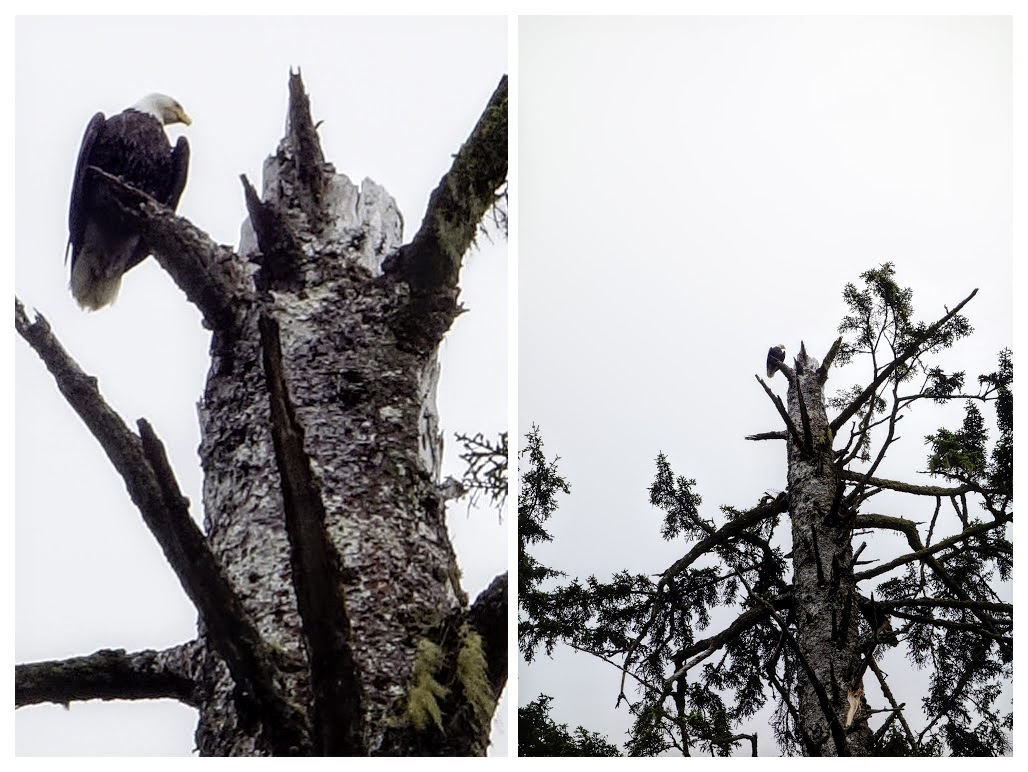 The receding tide exposed large swaths of seaweed-draped tide pools teeming with tiny little crabs. After dinner, we sat and watched a pair of bald eagles feasting on this bounty. They didn't seem too bothered by us: one or the other would fly down to the rocks at the edge of the water, grab something, and fly back up to the top of a nearby pine tree; then the process would be repeated. It looked like a pretty good setup.
Day 5: Laura Creek to Nissen Bight
 The hike had been getting progressively less difficult as we travelled westward. There was still mud in the forest, and ups and downs with ropes beside the trail, but they just didn't seem as relentlessly punishing as in the first couple of days. Or maybe we'd just become numb to it.
 The trail to Nissen Bight turned inland into the forest once we got to the western end of the beach. It was a forest hike pretty much all of this day, and while there were still extensive patches of mud, it was nowhere as intimidating as it had been earlier in the hike. We felt like seasoned Mud Warriors!

|

|

|
|

|

|
Day 6: Nissen Bight to San Josef Bay

The day had dawned overcast, a mist hugging the beach and obscuring the trees in the distance, but this burned off quickly and the sky was clear and blue by the time we broke camp and headed out. We stopped at the western edge of the beach to check out the tide pools that were uncovered at low tide. Nicole and Nirmal found a message in a bottle—some charming drawings that some young kids had launched and which had been found and re-launched; we added our names and re-re-launched the bottle.

|

|

At the west end of the beach the trail veered into the forest and headed straight south. The trees around us were huge, their tops soaring far above the ground (they seemed much taller here than earlier on the hike, but it's possible that I was preoccupied by the mud back there and wasn't paying attention to the trees).
This day's hike was by far the longest of our trek (15 km, i.e., 9 miles) but also the easiest. The trail was mostly pretty flat, with much of it boardwalked. We marched along determinedly and the kilometers fell rapidly.
We reached San Josef Bay in the mid-afternoon and gratefully dropped our packs on the pristine white sand of the nearly deserted beach. I set up my tent, despite the gusting wind (which made the tent act like a sail) and the sand (which made it impossible to stake it down); Nirmal and Nicole watched skeptically. Sure enough, the wind soon blew it over on its side even though I'd thrown the contents of my pack inside.
We whiled away the warm afternoon sitting around being lazy and carefree. Later, when we thought of it and went to get water, we found that the tide was coming in and we couldn't get to the water source easily. Luckily we had enough to get us through the night, so our lack of forethought didn't cost us too much. Dinner was in the shelter of an old dead tree stump. Eventually we crawled into our tents for the last night of this adventure.

|
|

|

|

|
|
 | |
Day 7. Out
 The van from Port Hardy was supposed to pick us up at the trailhead at 9:30. It was an easy walk over. The van showed up around 9, and we threw our packs in and clambered aboard, and the van turned around and headed back down towards Port Hardy. The hike was done.
Postscript
This was a challenging hike, both physically (the terrain) and mentally (unfamiliarity with forest hiking, not knowing what to expect), and took me well outside my comfort zone. That is a Good Thing, at least in retrospect. I had a lot of new experiences, saw a lot of new country, learned a lot of new things. That is also a Good Thing, and not just in retrospect.The experience would have been a lot more difficult without the patience and generosity of my friends and hosts, Nirmal and Nicole, who even pulled strings to arrange for perfect weather through the entirety of our hike. Thanks, guys! I'm looking forward to our next outing.


