Friday, December 17, 2021

Grand Canyon (Nankoweap Trail): Dec 2021

 At the very beginning of December 2021, Tom and I, together with our Canadian friends Nirmal and Nicole, spent five nights (six days) backpacking Nankoweap Trail off Grand Canyon's North Rim.  This is considered to be the hardest named trail in all of Grand Canyon, and in this it did not disappoint.  We didn't get to do everything we had planned, but it was an enjoyable hike nonetheless.

The Trail

Going just by the summary numbers, other than its length (14 miles from trailhead to river), Nankoweap doesn't seem any worse than other Grand Canyon trails: for example, its 4,840' elevation change from rim to river works out to an average drop of about 346 feet per mile; by contrast, Bright Angel Trail, with an average drop of 438 feet per mile (4,380' over 10 miles) seems quite a bit steeper.  Why, then, is this considered the hardest named trail in GCNP?

Of course, the summary numbers don't tell the full story.  There are actually two different things going on: steepness and exposure.

First, steepness.  Nankoweap's elevation profile looks like this (thanks to Tom Hickey for pointing this out to me):


For more than 11 out of its total 14 mile length (8.5 miles from the trailhead to Tilted Mesa, three miles from Nankoweak Creek down to the Colorado), Nankoweap Trail isn't particularly steep.  It sort of just moseys along: the campsite above Tilted Mesa, for example, 8.5 miles into the hike, is at almost the same elevation as the trailhead.  The action is all in the section from Tilted Mesa down to Nankoweap Creek, where the trail drops about 3,300' over 2.5 miles: a breathtaking 1,320 feet per mile!  There are sections where just looking down at what seems to be a near-vertical plunge of the trail is enough to weaken one's resolve.  This is, of course, reversed on the way back up the trail, when "breathtaking" takes on an entirely different meaning.

The second challenge is exposure.  For much of the "mosey-along" traverse of the Supai—from just below the canyon rim all the way to just above Tilted Mesa—the trail is narrow (often less than a foot wide), with a cliff rising steeply on one side and a cliff falling away steeply on the other.  Depending on one's sensitivity to vertiginous dropoffs, one's reaction to this can range from nonchalance to white-knuckled terror; for the same reason, one person's sincere "It's not too bad" assessment of the trail can come across to someone else as wildly inaccurate maybe to the point of lying.

This hike, it turned out, had a lot of character-building in the works.  But we didn't know that when we started out.

Day 0: Getting to the Trailhead

I picked up Nirmal and Nicole at their hotel near Sky Harbor Airport, rendezvous'd with Tom at Sunset Point Rest Stop, and headed north towards highway 89A.  We had planned to have a late lunch along the way, but the restaurant was closed and, wanting some daylight to set up camp, we decided not to wait.  FS 8910, the dirt road leading to the trailhead, was in worse shape than I remembered from our last visit, and my Honda Accord struggled at times.  

We reached the trailhead a little before dusk and quickly set up our tents at a campsite nearby.  Dinner was abbreviated.  The night was expected to be cold, so our preparations for the next day's hike—including packing enough water for a dry camp the following evening—included moving our water into our tents so that they didn't freeze overnight.  Tom started a fire, a little puddle of light in the dark night, that helped warm us.  We were all tired and didn't stay up very late. 

Days 1 and 2: Trailhead to Nankoweap Creek

We were up at 5 and had our packs on by 7:30.  The trail soon headed downhill towards a creek, meandered along the creekbed for a little while, then headed uphill towards the base of Saddle Mountain and the edge of the rim, about a thousand feet above us.  We reached the rim around 11, took a short break to catch our breaths and enjoy the view, then headed down into the canyon.

The hike felt like hard work; it didn't help that I felt tired (surprisingly so considering the relatively gentle slope of the trail), possibly because of the skimpy dinner the night before.  

We reached Marion Point around 2, sat around for a bit, then set up camp.  Nicole was skeptical at first about pitching tents on a tiny postcard-sized campsite with cliffs falling away steeply on three sides, but eventually got used to the idea (the lack of any plausible alternatives may have been a persuading factor).

The rest of the afternoon was lazy.  We had an early dinner.  The temperature dropped quickly as soon as the sun went behind the cliffs.  Between the cold and our fatigue, we didn't wait around very long—I was in my tent by 5:30.


The next morning we were on the trail around 8.  It's a little less than six miles from Marion Point to Nankoweap Creek, and I'd figured that if we could sustain an average hiking speed of 1 mph, and accounting for breaks along the way, we'd get to the creek no later than 3.  But we moved slower than expected, and took 3 1/2 hours to cover the three miles to the top of Tilted Mesa.  Nirmal and Nicole weren't happy about the exposure along the Supai traverse, but pushed through with grim (and admirable) determination.  We descended slowly and carefully through the Redwall, and again down a long steep section through the Muav layer, and the shadows were beginning to lengthen by the time the trail began to flatten out towards the bottom.  The effects of fatigue were beginning to show: Nicole stumbled and fell at one point, hurting an ankle and knee.  


Daylight was waning by the time we reached Nankoweap Creek around 4:30.  We had enough light to set up our tents and purify some water before dark, but dinner was by the light of our headlamps.  I was in my tent by 6:30.

Days 3 and 4: Nankoweap Creek

Our original plan had been to hike up Kwagunt Canyon on Day 3 and back to Nankoweap over the Kwagunt-Nankoweap Saddle on Day 4.  At dinner the previous evening we'd agreed that this was perhaps too ambitious, and (since our backcountry permit had us over in Kwagunt Canyon on Night 3) settled instead on the plan of hiking over to Kwagunt Canyon along the river, then back the same way the following day—in effect cutting out the strenuous hike over the saddle while still staying legal with our permit.  But lying in my tent that morning, the more I thought about this the more convinced I became that, from a health and safety point of view, the prudent thing to do would be to rest and recuperate.  There were no howls of protest when I proposed this, and so the decision was made: we would make this an easy day, stay where we were, give our bodies plenty of horizontal time to recover; the day's hike would be to go down to the Colorado and visit the Granaries.

We began the day lazily, beginning the walk to the river around 10 and moseying down Nankoweap Creek slowly.  There was a little water in the creek, but enough room in the wide and flat and sandy bed to make for a very pleasant walk (though at one point I tripped on a fallen yucca stem and landed open-handed on a clump of prickly pear, ruining a perfectly good glove in the process).  We came across three or four people from rafting parties hiking upstream, but otherwise had the place to ourselves.  


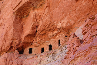
We reached the Granaries a little after 1, and after hanging out and enjoying the view for a while, headed back down to the creek and towards camp.  The hike back was quicker, possibly motivated by the fading daylight.  We reached camp just as the sun was setting.  To my relief, I didn't see any citation for being camped in the wrong area.  The rest of the evening was very pleasant and relaxed.  


One odd thing we noticed was the behavior of a pair of birds—what I later found were black-headed grosbeaks—right by our campsite.  As we moved around camp in the morning they was flitting around in the bushes, rustling the leaves loudly.  When we returned to camp late that afternoon, many hours later, they were still rustling around that same little spot of ground, chirping loudly all the while.  This behavior was puzzling—especially the incessant loud chirping, which drew attention to them and surely expended a good deal of energy in a place where food couldn't have been plentiful.  Possibly we were camped too close to their nest?  

The next day—the fourth day of our hike, and our last at Nankoweap Creek—was, by general consensus, an "in camp" rest day.  The morning began lazily, with everyone enjoying the warmth and comfort of their tents, no one in a hurry to be up and about.  This lack of urgency gave me the rare luxury of being able to lie back and listen to the sounds around me.  Closest, of course, just a few feet away from my tent, were the grosbeaks, who had been kicking up a ruckus since sunrise (digging? foraging for bugs?) in the same little thicket of bushes.  Further away, in the background, was the soft burbling of Nankoweap Creek.  Every so often a dead cottonwood leaf would drift down from a nearby tree and slide down the side of my tent, rustling softly like slow-motion rain.  We spent most of the day relaxing by the creek, enjoying the cloudless blue sky and soaking in the gentle winter sunlight. 

The rest day eased our aches but didn't erase all the pain.  Some time after dinner, as we were going about various chores around camp, I said something about how wonderful it was to have encountered so few other people.  Nicole responded that that was because "only very few hikers would be stupid enough to come to this place."  In mute wonder I gazed at the cliffs surrounding us soaring to the sky, luminous in the light of the setting sun.

Days 5 and 6: Nankoweap Creek to Trailhead

We were up by 4:30 and on the trail heading out of Nankoweap Creek a little after 6.  Initially we hiked by the light of our headlamps, able to see only the small illuminated area in front of our feet.  Little by little the bland darkness around us took shape: first the cliff and hills in the distance, silhouetted faintly across the faintly lightening sky; then, closer by, clots and blobs that slowly resolved into rocks and bushes and trees.  By 7 we had our headlamps off.  The air was cool and the hiking delightful.  We reached the campsite above Tilted Mesa around mid-day.  There was no particular enthusiasm among the group to keep hiking to the next plausible campsite at Marion Point, so after sitting around for a bit and having lunch, we set up camp.  I lay in my tent, warmed by the mellow sunshine, and may have snoozed for a while.

Much to my astonishment, I found I had a cell signal.  Somewhat guiltily I checked my email and the news headlines; the takeaway was that, as far as I could tell, the world had gotten by just fine in my absence.

As on the other days of this trip, the temperature dropped quickly once the sun dropped behind the cliffs.  I stayed up a little bit watching the western sky change color.  The crags and canyons below us slowly lost shape and faded into darkness.  A very thin sliver of moon appeared above Mt. Hayden.  I headed into my tent; the time was 5:30.

The plan the next morning was to hit the trail by 7, right around sunrise.  When I began packing up my gear around 5:30, it was pitch dark with what seemed like a billion glittering jewels strewn across the sky; the familiar constellations were all there, old friends keeping me company as I went about my mundane chores.  

Slowly, almost imperceptibly, the sky over to the east lightened and a faint horizon appeared.  Gradually, very gradually and in utter still silence, shapes began to emerge from the undifferentiated darkness: mesas and buttes and gullies first; then, closer by, trees, rocks, and scrub bushes.  Then, over a span of maybe fifteen minutes, the eastern sky exploded with purple and orange and red, lighting up a few thin wisps of cloud that hung low in the sky, like a celestial celebration of Holi.  The sun finally popped above the horizon just as we shouldered our packs and began hiking.  Suddenly there were shadows.  The Supai cliffs above us glowed a luminous red-gold.  Morning had broken, like the first morning.

The hiking was a lot easier at this point: our packs were a lot lighter (no more food, no extra water for dry camps), and the trail ambled along agreeably with none of the ferocious uphill slog of the previous day.  I found myself hanging back, both to take pictures at my leisure but also to enjoy the silence and solitude of the Canyon on the last day of our trip.


 The trail wound its way through the Supai layer, just as exposed as it had been on our way down a few days ago but somehow not quite so fearsome.  The rock turrets above Marion Point gradually grew larger.  We reached Marion Point around 11, paused briefly for lunch, then resumed the hike.  A thin veil of clouds filtered just enough of the weak sunshine to make for a perfect hiking temperature.  The Canyon was hazy with what seemed to be smoke, maybe from a prescribed burn somewhere.  We reached the rim a little after 1.  After a short break we headed downhill towards the trailhead.  Those last three miles were easy but seemed interminable.  But little by little the miles fell away; we reached our cars around 3:30 pm.

More pictures: https://photos.app.goo.gl/BiTu73k4PzdTCirq8


Thursday, November 25, 2021

Grand Canyon (New Hance to Grandview): Nov 2021

Over Veteran's Day (Nov 2021), Rui, Tom, and I did a quick three-night/four-day hike in the Grand Canyon, going down New Hance Trail on Nov 11 and coming out on Grandview Trail on Nov 14.  This is one of my favorite South Rim hikes, for several reasons.  First, New Hance is a challenging trail (one of the most difficult on the South Rim), so it doesn't get a lot traffic, which makes for plenty of solitude and a wonderful backcountry experience; the lack of crowds also makes it easier to get permits.  Second, it's relatively short---it can be done as a two-night backpacking trip---which makes scheduling easier.  Finally, it's geologically fascinating: at one end, Red Canyon (which New Hance goes down) cuts through the colorful layers of the Supergroup, the bright orange-red of the Hakatai Shale among the most conspicuous of them; then, as one treks west along the Tonto, the rock layers gradually rise up and by the time one reaches Hance Canyon a few miles away the crazy chaotic mess of the black Vishnu Schist basement layer is on full display; at the other end, going up Grandview Trail, the ground is strewn with green-flecked rock shards from copper minerals that formed the basis of mines in this area a century ago.  In a landscape where gorgeous is routine, this hike stands out as stunning.

I stayed in Tom's cabin near Valle the evening before the hike.  We drove up towards GCNP's South Entrance in the pre-dawn darkness to get Rui and head for the trailhead; the six miles separating the endpoints of our hike, and the resulting need to leave a vehicle at each end, made this slightly more involved than otherwise.  The sky was just beginning to lighten at this point, the landscape gradually resolving into shades of light and dark gray, and twice I had to hit the brake hard to avoid running into elk claiming ownership of the road.  But mishaps were averted, and after a minor detour from initially missing the unmarked spot leading to New Hance trailhead, we put our packs on and headed down.  It was around 7:30 AM, and the sun was just beginning to be visible above the Canyon Rim.

Day 1. New Hance Trailhead to Hance Rapids

Once one starts down New Hance it quickly becomes clear why there are so few people on this trail.  At 6.5 miles it's the shortest  of all rim-to-river trails on the South Rim (and since the total elevation drop is roughly the same for all of them, therefore also the steepest).   The trail drops steeply and relentlessly; the long slogs across interminable Supai traverses, so characteristic of other GC trails, are much abbreviated.  The rock layers go by quickly.

Rui straightening his bent hiking pole
We picked our way down the steep, loose, rocky trail carefully.  Progress was slow.  At one point Rui accidentally ran into his hiking poles and bent one of them; to my pleasant surprise, he was able to straighten it back, and they worked out fine for the rest of the hike.  

Crossing a rock slide
The trail seemed harder than it had been a couple of years ago.  It looked like the trail had suffered from an unusually wet monsoon season.  Rock slides had buried the trail in a number of places, needing us to boulder-hop carefully across them, hoping that a stable-looking rock wouldn't suddenly shift underfoot.  The trail had washed away at other places, leaving gaps to be stepped across gingerly. There was more exposure than I remembered.

Redwall Cliffs
We were at the top of the Redwall by around noon-ish, stopped briefly for lunch at one of the campsites below the Redwall, and were down by the floor of Red Canyon a little after 2pm.  There was a thin trickle of water flowing---enough to be reassuring, but not enough for a convenient overnight camp.  Tom was feeling tired at this point (and I'll admit the relentless downhill had left my quads and calves achy as well), so Rui and I went ahead while Tom followed more slowly.  We reached the Colorado around 3:30pm, scouted around for a bit, and were in the process of setting up camp when Tom showed up.  We sat around and relaxed for a bit, finished our camp setup chores, and had an early dinner.  

It got dark soon after the sun set around 5:30.  I was tired and fled into my tent by 6:30.  There was about a half-moon out, which seemed pretty bright in the darkness of the Canyon, but I was tired from the day's hike.  With the soothing background roar of Hance Rapids drowning out all other sounds, I don't think I was awake very long.

The evening had been delightfully pleasant, and I had decided to leave my rain fly off overnight.  When I woke up some time during the night, after moonset, the sky above me was an ocean of glittering jewels: the Big Dipper rotating into view above the cliffs just across the river from us; the familiar W of Cassiopeia astride the Milky Way above me; and Orion standing guard further south.  I don't think I will ever get tired of this treat.

Day 2: Day hike to Papago Canyon

The cliffs above Hance Rapids in morning sunlight

This was a rest day, and there was no pressing need to be up and about early.  After a leisurely breakfast we moved our camp to a shadier spot closer to water.  Tom decided to stay behind at camp, so Rui and I headed out east for a day hike along the Escalante Route, which Tom and I had hiked a year earlier.  

We soon came to the Papago Slide, this time approaching it from the west.  Going up the Slide seemed easier than coming down; it helped that I had come down the Slide a year ago and so had appropriately lowered expectations.  I went up first, and Rui came after me once I hollered down that I was clear.  He zipped up so quickly that I didn't have time to get a picture of him coming up!  

Papago Slide

We reached Papago Canyon maybe ten or fifteen minutes after coming up Papago Slide.  I had last been here heading east-to-west on the Escalante Route, and things looked quite different coming in the other direction.  We stood confusedly for a while at the top of Papago Canyon, staring at the map on my phone, my mind refusing to accept that the trail lay below what seemed to be a vertical cliff in front of us. Once we finally figured out where we needed to be,  and scrambled down the short distance to the top of Papago Wall, I found myself singularly unenthused about climbing down the short cliff face.  Eventually, after much hemming and hawing, I went down and Rui came down after me.  As on the previous trip, the issue was more mental than physical, and once I began the downclimb it went quickly and uneventfully.  Rui and I had lunch by the river.  We had the place entirely to ourselves (in fact, we hadn't seen a single person since we left camp that morning), and it was quite lovely.

On the way to Papago Canyon

Papago Canyon looked like a pretty cool slot canyon, and after lunch we thought we might try to hike up the canyon for a bit.  Unfortunately we weren't able to find a plausible way down into the canyon where we could also be confident about our ability to get back out afterwards.  Eventually we gave up and headed back towards camp.

Papago Canyon

While we were on top of the cliff above Papago Wall, we spotted two small inflatable rafts going down the river.  Afterwards, we found out from Tom that they were both Park Rangers, one of them someone we had met when hiking Boucher with the Johannesmeyers in 2020.  

When we got back to camp, we found that Tom had hurt his back and movement---even routine movement, like standing up or sitting down---was uncomfortable.  This was a bummer.  

The rest of the day was pleasant and uneventful.  I was in my tent before 7pm.

Approaching dusk: cliffs at Hance Rapids

Day 3. Hance Rapids to Hance Creek

A mellow day of hiking: 6.5 miles, with an elevation gain of about 1100' climbing from Hance Rapids to the Tonto, almost all of which happens in the first mile or so out of Hance Rapids, which means that most of the remaining 5.5 miles is "Tonto flat"---mostly contouring along, with occasional ups and downs but nothing really big.  We got on the trail a little after 8 AM.  The weather was perfect, with a blue sunny sky and pleasantly warm temperatures.  The hike to Hance Creek was delightful, and we had the campsite entirely to ourselves.  The only people we saw through the entire day were: a group what looked like a bunch of Boy Scouts and two trail runners who breezed through Hance Creek as we were setting up camp.


Day 4: Hance Creek to Grandview Point

Taking down camp
The last day of our hike: 5 miles to the rim at Grandview Point, with an elevation change of 3700'.  We were up by 5:30 and hiking by 7:30.  The trail stayed flat over the short half-mile stretch of Tonto from Hance Creek to the junction with Hance Creek Trail, then began climbing, growing steadily steeper and rougher as we got higher.  As with the descent on New Hance (though nowhere as bad), the trail seemed more difficult than I remembered it from my last visit, possibly due to the effects of a very wet monsoon season: at several places, mostly while going through the Redwall, we had to climb over rock slides or step across washed out sections.  

The ascent through the Redwall layer is a steep hard loose rocky slog on every Grand Canyon trail I've hiked; the reward at the end is often simply the relief that the relentless uphill will be replaced, at least for a while, by a kinder-on-the-lungs traverse through the Supai.  The Redwall section of Grandview is just as steep a slog as the others, but comes with a unique treat: as one approaches the top, the ground is increasingly strewn with bright green and blue flecks of copper ore.  I expect a lot of these brightly colored rocks have disappeared over the years, but what is left is still beautiful.

Remnants of the Last Chance Mine

We took a break for lunch at the top of Horseshoe Mesa, sitting in the shade of some junipers and enjoying the cloudless blue sky, the sunlit cliffs in the distance, the quiet and solitude.  The ground around us was littered with shards of broken glass and ceramic plates, and a few yards away the remains of an old iron bedframe lay rusting in the sun: artifacts left over from a time when mining was active, now considered historical and protected.

After a while we reluctantly put our packs back on and headed uphill.  The trail climbed steadily, we huffed and puffed our way up switchback after switchback, and the sun slowly slid across the sky.  The last several hundred vertical feet, through the upper rock layers, were slow going.  We reached the top some time around 3:30.


Grand Canyon (Escalante Route): April 2026

A group of six of us—Bill, Brett, Layne, Logan, Ramesh, and I—went on a four-day backpacking trip in Grand Canyon in April 2026: down Tanner...